Rožaje geodata
Rožaje (Opština Rožaje) is a seat of a first-order administrative division; located in Montenegro in Europe/Podgorica (GMT+2) time zone. With population of 9,121 people, there are 10 cities with bigger population in this country. Compared to other cities in Montenegro, 84.1% of cities are located further ↓South; 100% of cities are located further ←West and 95.2% of cities have lower elevation than Rožaje. Note1


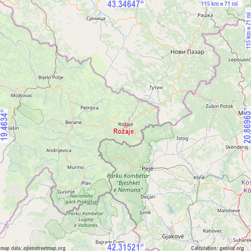
Rožaje GPS coordinates[2]
42° 49' 58.764" North, 20° 9' 59.472" East
| Map corner | latitude | longitude |
|---|---|---|
| Upper-left | 43.34647°, | 19.4634° |
| Center: | 42.83299°, | 20.16652° |
| Lower-right: | 42.31521°, | 20.86965° |
| Map W x H: | 114.7×114.7 km | = 71.3×71.3mi |
| max Lat: | 43.38472° ⇑15.9% North |
| Rožaje: | 42.83299° |
| min Lat: | ⇓84.1% South 41.92936° |
| min Long | Rožaje | max Long |
| 18.50647° | 20.16652° | 20.16652° |
| W 100%⇐ | ⇒0% E |
Elevation
Elevation of Rožaje is 1081 m = 3547 ft, and this is 735 m = 2411 ft above average elevation for this country.
| Max E: |
1448 m = 4751 ft | 4.8% |
| Rožaje | 1081 m 3547 ft | |
| Avg. | 346 m = 1135 ft | |
Min E: |
4 m = 13 ft | 95.2% |
See also: Montenegro elevation on elevation.city.
Geographical zone
Rožaje is located in North temperate zone (between Tropic of Cancer and the Arctic Circle). Distance of this Northern Tropic circle is 2156.7 km =1340.1 mi to South.| Distance of | km | miles | from Rožaje |
|---|---|---|---|
| North Pole | 5244.5 | 3258.8 | to North |
| Arctic Circle | 2638.6 | 1639.5 | to North |
| Tropic Cancer | 2156.7 | 1340.1 | to South |
| Equator | 4762.6 | 2959.3 | to South |


Nearby cities:
15 places around Rožaje: (largest is in red/bold)
• Andrijevica
32.5 km =20.2 mi,  250°
250°
• Barice
62.3 km =38.7 mi,  297°
297°
• Berane
23.9 km =14.9 mi,  272°
272°
• Bijelo Polje
41 km =25.5 mi, 303°
• Dinoša
81.9 km =50.9 mi,  235°
235°
• Dučice
86.1 km =53.5 mi,  261°
261°
• Gusinje
40.6 km =25.2 mi,  222°
222°
• Kolašin
53 km =32.9 mi, 268°
• Mojkovac
49.6 km =30.8 mi,  286°
286°
• Petnjica
18.5 km =11.5 mi, 297°
• Plav
31.9 km =19.8 mi,  214°
214°
• Podgorica
85.8 km =53.3 mi, 239°
• Prnjavor
31.5 km =19.6 mi, 214°
• Stijena
82 km =51 mi, 244°
• Tuzi
85.9 km =53.4 mi,  232°
232°
Sources, notices
• [Note1] Compared only with cities in Montenegro existing in our database
• [Src1] Map data: © OpenStreetMap contributors (CC-BY-SA)
• [Src2] Other city data from geonames.org with taken over terms of usage.
• [Src3] Geographical zone / Annual Mean Temperature by Robert A. Rohde @ Wikipedia
