Berane geodata
Berane is a seat of a first-order administrative division; located in Montenegro in Europe/Podgorica (GMT+2) time zone. With population of 11,073 people, there are 8 cities with bigger population in this country. Compared to other cities in Montenegro, 85.7% of cities are located further ↓South; 93.7% of cities are located further ←West and 69.8% of cities have lower elevation than Berane. Note1


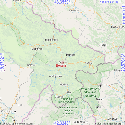
Berane GPS coordinates[2]
42° 50' 33" North, 19° 52' 23.988" East
| Map corner | latitude | longitude |
|---|---|---|
| Upper-left | 43.3559°, | 19.17021° |
| Center: | 42.8425°, | 19.87333° |
| Lower-right: | 42.3248°, | 20.57646° |
| Map W x H: | 114.6×114.6 km | = 71.2×71.2mi |
| max Lat: | 43.38472° ⇑14.3% North |
| Berane: | 42.8425° |
| min Lat: | ⇓85.7% South 41.92936° |
| min Long | Berane | max Long |
| 18.50647° | 19.87333° | 20.16652° |
| W 93.7%⇐ | ⇒6.3% E |
Elevation
Elevation of Berane is 676 m = 2218 ft, and this is 330 m = 1083 ft above average elevation for this country.
| Max E: |
1448 m = 4751 ft | 30.2% |
| Berane | 676 m 2218 ft | |
| Avg. | 346 m = 1135 ft | |
Min E: |
4 m = 13 ft | 69.8% |
See also: Montenegro elevation on elevation.city.
Geographical zone
Berane is located in North temperate zone (between Tropic of Cancer and the Arctic Circle). Distance of this Northern Tropic circle is 2157.7 km =1340.7 mi to South.| Distance of | km | miles | from Berane |
|---|---|---|---|
| North Pole | 5243.4 | 3258.1 | to North |
| Arctic Circle | 2637.5 | 1638.9 | to North |
| Tropic Cancer | 2157.7 | 1340.7 | to South |
| Equator | 4763.6 | 2960 | to South |


Nearby cities:
15 places around Berane: (largest is in red/bold)
• Andrijevica
13.8 km =8.6 mi,  208°
208°
• Barice
41.7 km =25.9 mi,  310°
310°
• Bijelo Polje
24.1 km =15 mi,  334°
334°
• Dinoša
64.3 km =40 mi,  222°
222°
• Dučice
62.8 km =39 mi,  256°
256°
• Gusinje
31.4 km =19.5 mi,  185°
185°
• Kolašin
29.2 km =18.1 mi,  265°
265°
• Kuta
62.6 km =38.9 mi, 259°
• Mojkovac
27 km =16.8 mi,  299°
299°
• Petnjica
10.5 km =6.5 mi,  45°
45°
• Plav
27.9 km =17.3 mi,  167°
167°
• Prnjavor
27.9 km =17.3 mi, 166°
• Rožaje
23.9 km =14.9 mi,  92°
92°
• Stijena
61.8 km =38.4 mi,  234°
234°
• Šavnik
64.5 km =40.1 mi,  281°
281°
Sources, notices
• [Note1] Compared only with cities in Montenegro existing in our database
• [Src1] Map data: © OpenStreetMap contributors (CC-BY-SA)
• [Src2] Other city data from geonames.org with taken over terms of usage.
• [Src3] Geographical zone / Annual Mean Temperature by Robert A. Rohde @ Wikipedia
