Budva geodata
Budva is a seat of a first-order administrative division; located in Montenegro in Europe/Podgorica (GMT+2) time zone. With population of 18,000 people, there are 4 cities with bigger population in this country. Compared to other cities in Montenegro, 87.3% of cities are located further ↑North; 71.4% of cities are located further →East and 90.5% of cities have higher elevation than Budva. Note1


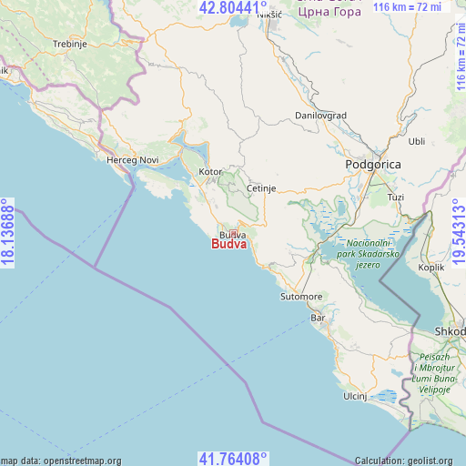
Budva GPS coordinates[2]
42° 17' 11.004" North, 18° 50' 24" East
| Map corner | latitude | longitude |
|---|---|---|
| Upper-left | 42.80441°, | 18.13688° |
| Center: | 42.28639°, | 18.84° |
| Lower-right: | 41.76408°, | 19.54313° |
| Map W x H: | 115.7×115.7 km | = 71.9×71.9mi |
| max Lat: | 43.38472° ⇑87.3% North |
| Budva: | 42.28639° |
| min Lat: | ⇓12.7% South 41.92936° |
| min Long | Budva | max Long |
| 18.50647° | 18.84° | 20.16652° |
| W 28.6%⇐ | ⇒71.4% E |
Elevation
Elevation of Budva is 7 m = 23 ft, and this is 339 m = 1112 ft below average elevation for this country.
| Max E: |
1448 m = 4751 ft | 90.5% |
| Avg. | 346 m = 1135 ft | |
| Budva | 7 m = 23 ft | |
Min E: |
4 m = 13 ft | 9.5% |
See also: Montenegro elevation on elevation.city.
Geographical zone
Budva is located in North temperate zone (between Tropic of Cancer and the Arctic Circle). Distance of this Northern Tropic circle is 2095.9 km =1302.3 mi to South.| Distance of | km | miles | from Budva |
|---|---|---|---|
| North Pole | 5305.3 | 3296.6 | to North |
| Arctic Circle | 2699.4 | 1677.3 | to North |
| Tropic Cancer | 2095.9 | 1302.3 | to South |
| Equator | 4701.8 | 2921.6 | to South |


Nearby cities:
15 places around Budva: (largest is in red/bold)
• Baošići
24.5 km =15.2 mi,  315°
315°
• Bečići
2.4 km =1.5 mi,  96°
96°
• Bijela
24 km =14.9 mi, 320°
• Cetinje
13.1 km =8.1 mi,  27°
27°
• Dobrota
19.6 km =12.2 mi,  342°
342°
• Donja Lastva
21.4 km =13.3 mi, 324°
• Kotor
16.1 km =10 mi, 338°
• Mrčevac
17.9 km =11.1 mi,  326°
326°
• Muo
17.5 km =10.9 mi, 337°
• Njeguši
16.6 km =10.3 mi,  351°
351°
• Petrovac na Moru
12.3 km =7.6 mi,  136°
136°
• Prčanj
20.7 km =12.9 mi, 337°
• Sutomore
23.3 km =14.5 mi,  133°
133°
• Tivat
20.4 km =12.7 mi, 324°
• Škaljari
15.9 km =9.9 mi, 337°
Sources, notices
• [Note1] Compared only with cities in Montenegro existing in our database
• [Src1] Map data: © OpenStreetMap contributors (CC-BY-SA)
• [Src2] Other city data from geonames.org with taken over terms of usage.
• [Src3] Geographical zone / Annual Mean Temperature by Robert A. Rohde @ Wikipedia
