Njeguši geodata
Njeguši (Cetinje) is a populated place; located in Montenegro in Europe/Podgorica (GMT+2) time zone. With population of 517 people, there are 58 cities with bigger population in this country. Compared to other cities in Montenegro, 61.9% of cities are located further ↑North; 74.6% of cities are located further →East and 85.7% of cities have lower elevation than Njeguši. Note1


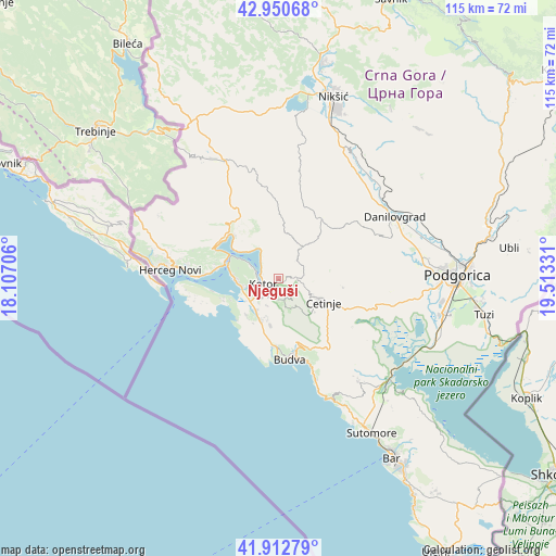
Njeguši GPS coordinates[2]
42° 26' 1.968" North, 18° 48' 36.648" East
| Map corner | latitude | longitude |
|---|---|---|
| Upper-left | 42.95068°, | 18.10706° |
| Center: | 42.43388°, | 18.81018° |
| Lower-right: | 41.91279°, | 19.51331° |
| Map W x H: | 115.4×115.4 km | = 71.7×71.7mi |
| max Lat: | 43.38472° ⇑61.9% North |
| Njeguši: | 42.43388° |
| min Lat: | ⇓38.1% South 41.92936° |
| min Long | Njeguši | max Long |
| 18.50647° | 18.81018° | 20.16652° |
| W 25.4%⇐ | ⇒74.6% E |
Elevation
Elevation of Njeguši is 906 m = 2972 ft, and this is 560 m = 1837 ft above average elevation for this country.
| Max E: |
1448 m = 4751 ft | 14.3% |
| Njeguši | 906 m 2972 ft | |
| Avg. | 346 m = 1135 ft | |
Min E: |
4 m = 13 ft | 85.7% |
See also: Montenegro elevation on elevation.city.
Geographical zone
Njeguši is located in North temperate zone (between Tropic of Cancer and the Arctic Circle). Distance of this Northern Tropic circle is 2112.3 km =1312.5 mi to South.| Distance of | km | miles | from Njeguši |
|---|---|---|---|
| North Pole | 5288.9 | 3286.4 | to North |
| Arctic Circle | 2683 | 1667.1 | to North |
| Tropic Cancer | 2112.3 | 1312.5 | to South |
| Equator | 4718.2 | 2931.8 | to South |


Nearby cities:
15 places around Njeguši: (largest is in red/bold)
• Baošići
14.8 km =9.2 mi,  273°
273°
• Bijela
12.9 km =8 mi,  279°
279°
• Budva
16.6 km =10.3 mi,  171°
171°
• Cetinje
9.8 km =6.1 mi,  119°
119°
• Dobrota
4.1 km =2.5 mi,  303°
303°
• Donja Lastva
10 km =6.2 mi, 275°
• Kotor
3.7 km =2.3 mi,  246°
246°
• Lipci
14.3 km =8.9 mi, 299°
• Mrčevac
7.7 km =4.8 mi,  258°
258°
• Muo
4.3 km =2.7 mi, 266°
• Perast
10.9 km =6.8 mi, 302°
• Prčanj
6.2 km =3.9 mi, 295°
• Risan
13 km =8.1 mi,  313°
313°
• Tivat
9.4 km =5.8 mi, 271°
• Škaljari
4 km =2.5 mi,  244°
244°
Sources, notices
• [Note1] Compared only with cities in Montenegro existing in our database
• [Src1] Map data: © OpenStreetMap contributors (CC-BY-SA)
• [Src2] Other city data from geonames.org with taken over terms of usage.
• [Src3] Geographical zone / Annual Mean Temperature by Robert A. Rohde @ Wikipedia
