Kotor geodata
Kotor is a seat of a first-order administrative division; located in Montenegro in Europe/Podgorica (GMT+2) time zone. With population of 5,345 people, there are 13 cities with bigger population in this country. Compared to other cities in Montenegro, 65.1% of cities are located further ↑North; 77.8% of cities are located further →East and 98.4% of cities have higher elevation than Kotor. Note1


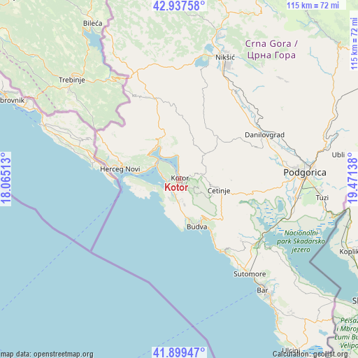
Kotor GPS coordinates[2]
42° 25' 14.412" North, 18° 46' 5.7" East
| Map corner | latitude | longitude |
|---|---|---|
| Upper-left | 42.93758°, | 18.06513° |
| Center: | 42.42067°, | 18.76825° |
| Lower-right: | 41.89947°, | 19.47138° |
| Map W x H: | 115.4×115.4 km | = 71.7×71.7mi |
| max Lat: | 43.38472° ⇑65.1% North |
| Kotor: | 42.42067° |
| min Lat: | ⇓34.9% South 41.92936° |
| min Long | Kotor | max Long |
| 18.50647° | 18.76825° | 20.16652° |
| W 22.2%⇐ | ⇒77.8% E |
Elevation
Elevation of Kotor is 5 m = 16 ft, and this is 341 m = 1119 ft below average elevation for this country.
| Max E: |
1448 m = 4751 ft | 98.4% |
| Avg. | 346 m = 1135 ft | |
| Kotor | 5 m = 16 ft | |
Min E: |
4 m = 13 ft | 1.6% |
See also: Montenegro elevation on elevation.city.
Geographical zone
Kotor is located in North temperate zone (between Tropic of Cancer and the Arctic Circle). Distance of this Northern Tropic circle is 2110.8 km =1311.6 mi to South.| Distance of | km | miles | from Kotor |
|---|---|---|---|
| North Pole | 5290.3 | 3287.2 | to North |
| Arctic Circle | 2684.4 | 1668 | to North |
| Tropic Cancer | 2110.8 | 1311.6 | to South |
| Equator | 4716.7 | 2930.8 | to South |


Nearby cities:
15 places around Kotor: (largest is in red/bold)
• Baošići
11.6 km =7.2 mi,  282°
282°
• Bijela
9.9 km =6.2 mi,  291°
291°
• Cetinje
12.4 km =7.7 mi,  105°
105°
• Dobrota
3.7 km =2.3 mi,  0°
0°
• Donja Lastva
7 km =4.3 mi, 290°
• Lipci
12.4 km =7.7 mi,  313°
313°
• Mrčevac
4.1 km =2.5 mi,  268°
268°
• Muo
1.5 km =0.9 mi,  324°
324°
• Njeguši
3.7 km =2.3 mi,  66°
66°
• Perast
9.3 km =5.8 mi, 322°
• Prčanj
4.6 km =2.9 mi,  332°
332°
• Risan
12.1 km =7.5 mi, 330°
• Tivat
6.2 km =3.9 mi, 286°
• Ðenovići
13.7 km =8.5 mi, 277°
• Škaljari
0.3 km =0.2 mi,  213°
213°
Sources, notices
• [Note1] Compared only with cities in Montenegro existing in our database
• [Src1] Map data: © OpenStreetMap contributors (CC-BY-SA)
• [Src2] Other city data from geonames.org with taken over terms of usage.
• [Src3] Geographical zone / Annual Mean Temperature by Robert A. Rohde @ Wikipedia
