Ambohitrolomahitsy geodata
Ambohitrolomahitsy (Analamanga) is a populated place; located in Madagascar in Indian/Antananarivo (GMT+3) time zone. With population of 17,000 people, there are 72 cities with bigger population in this country. Compared to other cities in Madagascar, 63.4% of cities are located further ↓South; 51.2% of cities are located further ←West and 93.5% of cities have lower elevation than Ambohitrolomahitsy. Note1
Administrative division(s):
- Level 1: Analamanga
- Level 2: Manjakandriana
- Level 3: Ambohitrolomahitsy
- Level 4: Ambohitrerana


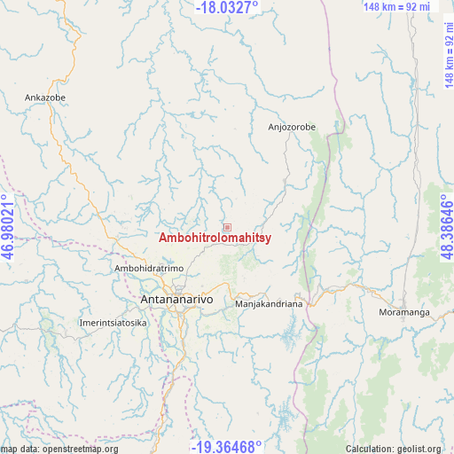
Ambohitrolomahitsy GPS coordinates[2]
18° 42' 0" South, 47° 40' 59.988" East
| Map corner | latitude | longitude |
|---|---|---|
| Upper-left | -18.0327°, | 46.98021° |
| Center: | -18.7°, | 47.68333° |
| Lower-right: | -19.36468°, | 48.38646° |
| Map W x H: | 148.1×148.1 km | = 92×92mi |
| max Lat: | -12.31732° ⇑36.6% North |
| Ambohitrolomahitsy: | -18.7° |
| min Lat: | ⇓63.4% South -25.3° |
| min Long | Ambohitrolomahi | max Long |
| 43.65° | 47.68333° | 50.27876° |
| W 51.2%⇐ | ⇒48.8% E |
Elevation
Elevation of Ambohitrolomahitsy is 1502 m = 4928 ft, and this is 944.6 m = 3099 ft above average elevation for this country.
| Max E: |
1763 m = 5784 ft | 6.5% |
| Ambohitrolomahitsy | 1502 m 4928 ft | |
| Avg. | 557.4 m = 1829 ft | |
Min E: |
1 m = 3 ft | 93.5% |
See also: Madagascar elevation on elevation.city.
Geographical zone
Ambohitrolomahitsy is located in South Torrid zone (between Equator and Tropic of Capricorn). Distance of this Southern Tropic circle is 526.7 km =327.3 mi to South.| Distance of | km | miles | from Ambohitrolomahitsy |
|---|---|---|---|
| Equator | 2079.2 | 1292 | to North |
| Tropic Capricorn | 526.7 | 327.3 | to South |
| Antarctic Circle | 5321.9 | 3306.9 | to South |
| South Pole | 7927.8 | 4926.1 | to South |


Nearby cities:
15 places around Ambohitrolomahitsy: (largest is in red/bold)
• Alarobia
30.1 km =18.7 mi,  169°
169°
• Ambatolaona
34.5 km =21.4 mi,  138°
138°
• Ambohitrandriamanitra
43.9 km =27.3 mi, 166°
• Ambohitseheno
15.4 km =9.6 mi,  127°
127°
• Anjepy
17 km =10.6 mi, 168°
• Anjozorobe
38.6 km =24 mi,  30°
30°
• Ankazondandy
10.5 km =6.5 mi,  90°
90°
• Antananarivo
28.4 km =17.6 mi,  213°
213°
• Manjakandriana
27 km =16.8 mi,  152°
152°
• Mantasoa
38.6 km =24 mi,  155°
155°
• Merikanjaka
51.3 km =31.9 mi, 160°
• Miadanandriana
38.5 km =23.9 mi, 164°
• Nandihizana
22.5 km =14 mi, 171°
• Sadabe
7.6 km =4.7 mi,  13°
13°
• Sambaina
24.6 km =15.3 mi, 154°
Sources, notices
• [Note1] Compared only with cities in Madagascar existing in our database
• [Src1] Map data: © OpenStreetMap contributors (CC-BY-SA)
• [Src2] Other city data from geonames.org with taken over terms of usage.
• [Src3] Geographical zone / Annual Mean Temperature by Robert A. Rohde @ Wikipedia
