Mantasoa geodata
Mantasoa (Analamanga) is a populated place; located in Madagascar in Indian/Antananarivo (GMT+3) time zone. With population of 10,000 people, there are 91 cities with bigger population in this country. Compared to other cities in Madagascar, 51.2% of cities are located further ↓South; 62.6% of cities are located further ←West and 83.7% of cities have lower elevation than Mantasoa. Note1
Administrative division(s):
- Level 1: Analamanga
- Level 2: Manjakandriana
- Level 3: Mantasoa
- Level 4: Masombahiny


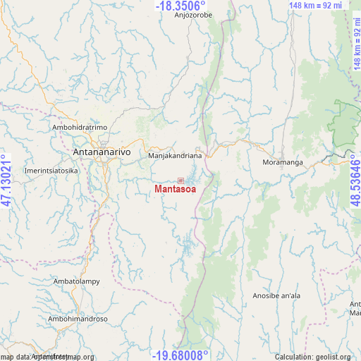
Mantasoa GPS coordinates[2]
19° 1' 0.012" South, 47° 49' 59.988" East
| Map corner | latitude | longitude |
|---|---|---|
| Upper-left | -18.3506°, | 47.13021° |
| Center: | -19.01667°, | 47.83333° |
| Lower-right: | -19.68008°, | 48.53646° |
| Map W x H: | 147.8×147.8 km | = 91.8×91.8mi |
| max Lat: | -12.31732° ⇑48.8% North |
| Mantasoa: | -19.01667° |
| min Lat: | ⇓51.2% South -25.3° |
| min Long | Mantasoa | max Long |
| 43.65° | 47.83333° | 50.27876° |
| W 62.6%⇐ | ⇒37.4% E |
Elevation
Elevation of Mantasoa is 1377 m = 4518 ft, and this is 819.6 m = 2689 ft above average elevation for this country.
| Max E: |
1763 m = 5784 ft | 16.3% |
| Mantasoa | 1377 m 4518 ft | |
| Avg. | 557.4 m = 1829 ft | |
Min E: |
1 m = 3 ft | 83.7% |
See also: Madagascar elevation on elevation.city.
Geographical zone
Mantasoa is located in South Torrid zone (between Equator and Tropic of Capricorn). Distance of this Southern Tropic circle is 491.5 km =305.4 mi to South.| Distance of | km | miles | from Mantasoa |
|---|---|---|---|
| Equator | 2114.5 | 1313.9 | to North |
| Tropic Capricorn | 491.5 | 305.4 | to South |
| Antarctic Circle | 5286.7 | 3285 | to South |
| South Pole | 7892.6 | 4904.2 | to South |


Nearby cities:
15 places around Mantasoa: (largest is in red/bold)
• Alarobia
11.9 km =7.4 mi,  297°
297°
• Ambatolaona
11.6 km =7.2 mi,  37°
37°
• Ambohitrandriamanitra
9.1 km =5.7 mi,  215°
215°
• Ambohitrolomahitsy
38.6 km =24 mi,  335°
335°
• Ambohitseheno
26.2 km =16.3 mi,  352°
352°
• Andramasina
31.9 km =19.8 mi,  233°
233°
• Anjepy
22.2 km =13.8 mi,  326°
326°
• Ankazondandy
35.6 km =22.1 mi, 351°
• Antananarivo
33.3 km =20.7 mi,  290°
290°
• Manjakandriana
11.7 km =7.3 mi, 342°
• Merikanjaka
13.1 km =8.1 mi,  172°
172°
• Miadanandriana
5.6 km =3.5 mi,  250°
250°
• Moramanga
42.4 km =26.3 mi,  79°
79°
• Nandihizana
17.9 km =11.1 mi,  316°
316°
• Sambaina
14 km =8.7 mi, 337°
Sources, notices
• [Note1] Compared only with cities in Madagascar existing in our database
• [Src1] Map data: © OpenStreetMap contributors (CC-BY-SA)
• [Src2] Other city data from geonames.org with taken over terms of usage.
• [Src3] Geographical zone / Annual Mean Temperature by Robert A. Rohde @ Wikipedia
