Ambatolaona geodata
Ambatolaona (Analamanga) is a populated place; located in Madagascar in Indian/Antananarivo (GMT+3) time zone. With population of 5,000 people, there are 110 cities with bigger population in this country. Compared to other cities in Madagascar, 56.1% of cities are located further ↓South; 65.9% of cities are located further ←West and 87% of cities have lower elevation than Ambatolaona. Note1
Administrative division(s):
- Level 1: Analamanga
- Level 2: Manjakandriana
- Level 3: Ambatolaona
- Level 4: Ambatolaona Est


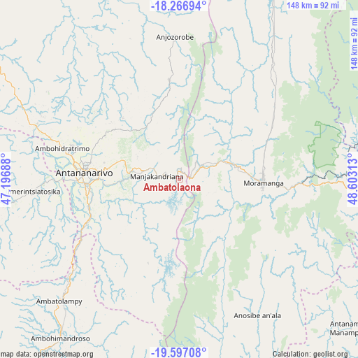
Ambatolaona GPS coordinates[2]
18° 55' 59.988" South, 47° 54' 0" East
| Map corner | latitude | longitude |
|---|---|---|
| Upper-left | -18.26694°, | 47.19688° |
| Center: | -18.93333°, | 47.9° |
| Lower-right: | -19.59708°, | 48.60313° |
| Map W x H: | 147.9×147.9 km | = 91.9×91.9mi |
| max Lat: | -12.31732° ⇑43.9% North |
| Ambatolaona: | -18.93333° |
| min Lat: | ⇓56.1% South -25.3° |
| min Long | Ambatolaona | max Long |
| 43.65° | 47.9° | 50.27876° |
| W 65.9%⇐ | ⇒34.1% E |
Elevation
Elevation of Ambatolaona is 1403 m = 4603 ft, and this is 845.6 m = 2774 ft above average elevation for this country.
| Max E: |
1763 m = 5784 ft | 13% |
| Ambatolaona | 1403 m 4603 ft | |
| Avg. | 557.4 m = 1829 ft | |
Min E: |
1 m = 3 ft | 87% |
See also: Madagascar elevation on elevation.city.
Geographical zone
Ambatolaona is located in South Torrid zone (between Equator and Tropic of Capricorn). Distance of this Southern Tropic circle is 500.7 km =311.1 mi to South.| Distance of | km | miles | from Ambatolaona |
|---|---|---|---|
| Equator | 2105.2 | 1308.1 | to North |
| Tropic Capricorn | 500.7 | 311.1 | to South |
| Antarctic Circle | 5296 | 3290.8 | to South |
| South Pole | 7901.9 | 4910 | to South |


Nearby cities:
15 places around Ambatolaona: (largest is in red/bold)
• Alarobia
17.9 km =11.1 mi,  258°
258°
• Ambohitrandriamanitra
20.7 km =12.9 mi,  216°
216°
• Ambohitrolomahitsy
34.5 km =21.4 mi,  318°
318°
• Ambohitseheno
19.7 km =12.2 mi,  327°
327°
• Anjepy
21.4 km =13.3 mi,  295°
295°
• Ankazondandy
28.7 km =17.8 mi, 334°
• Antananarivo
38.3 km =23.8 mi,  273°
273°
• Manjakandriana
10.7 km =6.6 mi,  279°
279°
• Mantasoa
11.6 km =7.2 mi, 217°
• Merikanjaka
22.9 km =14.2 mi,  193°
193°
• Miadanandriana
16.6 km =10.3 mi,  227°
227°
• Moramanga
34.8 km =21.6 mi,  92°
92°
• Nandihizana
19.6 km =12.2 mi, 280°
• Sadabe
39.4 km =24.5 mi, 327°
• Sambaina
12.8 km =8 mi,  286°
286°
Sources, notices
• [Note1] Compared only with cities in Madagascar existing in our database
• [Src1] Map data: © OpenStreetMap contributors (CC-BY-SA)
• [Src2] Other city data from geonames.org with taken over terms of usage.
• [Src3] Geographical zone / Annual Mean Temperature by Robert A. Rohde @ Wikipedia
