Rostusa geodata
Rostusa (Mavrovo and Rostuša) is a seat of a first-order administrative division; located in North Macedonia in Europe/Skopje (GMT+2) time zone. With population of 9,147 people, there are 53 cities with bigger population in this country. Compared to other cities in North Macedonia, 52.9% of cities are located further ↑North; 98.7% of cities are located further →East and 85.5% of cities have lower elevation than Rostusa. Note1


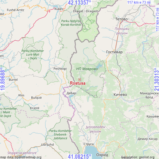
Rostusa GPS coordinates[2]
41° 36' 36" North, 20° 36' 0" East
| Map corner | latitude | longitude |
|---|---|---|
| Upper-left | 42.13357°, | 19.89688° |
| Center: | 41.61°, | 20.6° |
| Lower-right: | 41.08215°, | 21.30313° |
| Map W x H: | 116.9×116.9 km | = 72.6×72.6mi |
| max Lat: | 42.23276° ⇑52.9% North |
| Rostusa: | 41.61° |
| min Lat: | ⇓47.1% South 40.87556° |
| min Long | Rostusa | max Long |
| 20.52421° | 20.6° | 22.95624° |
| W 1.3%⇐ | ⇒98.7% E |
Elevation
Elevation of Rostusa is 789 m = 2589 ft, and this is 249.3 m = 818 ft above average elevation for this country.
| Max E: |
1382 m = 4534 ft | 14.5% |
| Rostusa | 789 m 2589 ft | |
| Avg. | 539.7 m = 1771 ft | |
Min E: |
62 m = 203 ft | 85.5% |
See also: North Macedonia elevation on elevation.city.
Geographical zone
Rostusa is located in North temperate zone (between Tropic of Cancer and the Arctic Circle). Distance of this Northern Tropic circle is 2020.7 km =1255.6 mi to South.| Distance of | km | miles | from Rostusa |
|---|---|---|---|
| North Pole | 5380.5 | 3343.3 | to North |
| Arctic Circle | 2774.6 | 1724.1 | to North |
| Tropic Cancer | 2020.7 | 1255.6 | to South |
| Equator | 4626.6 | 2874.8 | to South |


Nearby cities:
15 places around Rostusa: (largest is in red/bold)
• Centar Župa
15 km =9.3 mi,  192°
192°
• Debar
11.4 km =7.1 mi,  213°
213°
• Dolna Banjica
32.1 km =19.9 mi,  52°
52°
• Drugovo
30.5 km =19 mi,  117°
117°
• Gorni Dlapkin Dol
28.5 km =17.7 mi,  101°
101°
• Gorno Strogomište
30.4 km =18.9 mi,  90°
90°
• Gostivar
32.9 km =20.4 mi, 51°
• Kičevo
31.8 km =19.8 mi,  109°
109°
• Lukovo
28.5 km =17.7 mi,  178°
178°
• Mavrovi Anovi
16.6 km =10.3 mi, 51°
• Srbinovo
31.6 km =19.6 mi,  70°
70°
• Strelci
34.6 km =21.5 mi, 102°
• Vrapčište
34.4 km =21.4 mi,  43°
43°
• Vrutok
26.6 km =16.5 mi, 48°
• Zajas
28.1 km =17.5 mi, 90°
Sources, notices
• [Note1] Compared only with cities in North Macedonia existing in our database
• [Src1] Map data: © OpenStreetMap contributors (CC-BY-SA)
• [Src2] Other city data from geonames.org with taken over terms of usage.
• [Src3] Geographical zone / Annual Mean Temperature by Robert A. Rohde @ Wikipedia
