Fort-de-France geodata
Fort-de-France (Martinique) is a capital of a political entity; located in Martinique in America/Martinique (GMT-4) time zone. With population of 89,995 people, there are 0 cities with bigger population in this country. Compared to other cities in Martinique, 63.2% of cities are located further ↑North; 78.9% of cities are located further →East and 52.6% of cities have higher elevation than Fort-de-France. Note1
Administrative division(s):
- Level 1: Martinique
- Level 2: Martinique
- Level 3: Arrondissement de Fort-de-France
- Level 4: Fort-de-France


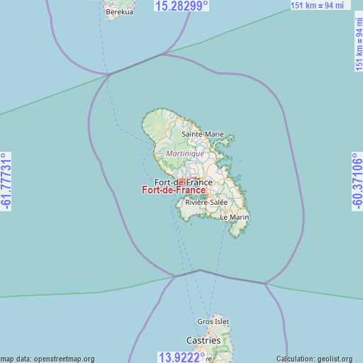
Fort-de-France GPS coordinates[2]
14° 36' 13.14" North, 61° 4' 27.048" West
| Map corner | latitude | longitude |
|---|---|---|
| Upper-left | 15.28299°, | -61.77731° |
| Center: | 14.60365°, | -61.07418° |
| Lower-right: | 13.9222°, | -60.37106° |
| Map W x H: | 151.3×151.3 km | = 94×94mi |
| max Lat: | 14.86935° ⇑63.2% North |
| Fort-de-France: | 14.60365° |
| min Lat: | ⇓36.8% South 14.46848° |
| min Long | Fort-de-France | max Long |
| -61.17541° | -61.07418° | -60.83831° |
| W 21.1%⇐ | ⇒78.9% E |
Elevation
Elevation of Fort-de-France is 17 m = 56 ft, and this is 43.8 m = 144 ft below average elevation for this country.
| Max E: |
459 m = 1506 ft | 52.6% |
| Avg. | 60.8 m = 199 ft | |
| Fort-de-France | 17 m = 56 ft | |
Min E: |
6 m = 20 ft | 47.4% |
See also: Fort-de-France elevation on elevation.city.
Geographical zone
Fort-de-France is located in North Torrid zone (between Equator and Tropic of Cancer). Distance of this Northern Tropic circle is 982.1 km =610.2 mi to North.| Distance of | km | miles | from Fort-de-France |
|---|---|---|---|
| North Pole | 8383.3 | 5209.1 | to North |
| Arctic Circle | 5777.4 | 3589.9 | to North |
| Tropic Cancer | 982.1 | 610.2 | to North |
| Equator | 1623.8 | 1009 | to South |


Nearby cities:
15 places around Fort-de-France: (largest is in red/bold)
• Ducos
11.2 km =7 mi,  106°
106°
• La Trinité
19.1 km =11.9 mi,  38°
38°
• Le François
18.5 km =11.5 mi,  86°
86°
• Le Gros-Morne
13.4 km =8.3 mi, 36°
• Le Lamentin
8.1 km =5 mi,  82°
82°
• Le Morne-Rouge
20.3 km =12.6 mi,  340°
340°
• Le Robert
16.4 km =10.2 mi,  59°
59°
• Les Trois-Îlets
8.4 km =5.2 mi,  148°
148°
• Rivière-Pilote
22.5 km =14 mi,  124°
124°
• Saint-Esprit
16.3 km =10.1 mi, 111°
• Saint-Joseph
8.4 km =5.2 mi,  26°
26°
• Saint-Pierre
18.9 km =11.7 mi,  324°
324°
• Sainte-Luce
22.3 km =13.9 mi,  132°
132°
• Sainte-Marie
21.9 km =13.6 mi,  23°
23°
• Schoelcher
3.1 km =1.9 mi,  300°
300°
In other languages:
- In France: Fort-de-France, Fort Royale
- In Russian: Форт-де-Франс, Фор-де-Франс
- In Chinese: 法兰西堡
Sources, notices
• [Note1] Compared only with cities in Martinique existing in our database
• [Src1] Map data: © OpenStreetMap contributors (CC-BY-SA)
• [Src2] Other city data from geonames.org with taken over terms of usage.
• [Src3] Geographical zone / Annual Mean Temperature by Robert A. Rohde @ Wikipedia
