Le Robert geodata
Le Robert (Martinique) is a populated place; located in Martinique in America/Martinique (GMT-4) time zone. With population of 23,814 people, there are 2 cities with bigger population in this country. Compared to other cities in Martinique, 63.2% of cities are located further ↓South; 68.4% of cities are located further ←West and 89.5% of cities have higher elevation than Le Robert. Note1
Administrative division(s):
- Level 1: Martinique
- Level 2: Martinique
- Level 3: Arrondissement de La Trinité
- Level 4: Le Robert


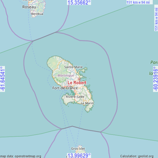
Le Robert GPS coordinates[2]
14° 40' 39.036" North, 60° 56' 32.208" West
| Map corner | latitude | longitude |
|---|---|---|
| Upper-left | 15.35662°, | -61.64541° |
| Center: | 14.67751°, | -60.94228° |
| Lower-right: | 13.99629°, | -60.23916° |
| Map W x H: | 151.3×151.3 km | = 94×94mi |
| max Lat: | 14.86935° ⇑36.8% North |
| Le Robert: | 14.67751° |
| min Lat: | ⇓63.2% South 14.46848° |
| min Long | Le Robert | max Long |
| -61.17541° | -60.94228° | -60.83831° |
| W 68.4%⇐ | ⇒31.6% E |
Elevation
Elevation of Le Robert is 8 m = 26 ft, and this is 52.8 m = 173 ft below average elevation for this country.
| Max E: |
459 m = 1506 ft | 89.5% |
| Avg. | 60.8 m = 199 ft | |
| Le Robert | 8 m = 26 ft | |
Min E: |
6 m = 20 ft | 10.5% |
See also: Martinique elevation on elevation.city.
Geographical zone
Le Robert is located in North Torrid zone (between Equator and Tropic of Cancer). Distance of this Northern Tropic circle is 973.9 km =605.2 mi to North.| Distance of | km | miles | from Le Robert |
|---|---|---|---|
| North Pole | 8375.1 | 5204 | to North |
| Arctic Circle | 5769.2 | 3584.8 | to North |
| Tropic Cancer | 973.9 | 605.2 | to North |
| Equator | 1632 | 1014.1 | to South |


Nearby cities:
15 places around Le Robert: (largest is in red/bold)
• Ducos
11.9 km =7.4 mi,  196°
196°
• Fort-de-France
16.4 km =10.2 mi,  239°
239°
• La Trinité
7.1 km =4.4 mi,  341°
341°
• Le François
8.1 km =5 mi,  148°
148°
• Le Gros-Morne
6.7 km =4.2 mi,  291°
291°
• Le Lamentin
9.4 km =5.8 mi,  220°
220°
• Le Lorrain
21.1 km =13.1 mi,  324°
324°
• Le Vauclin
18.5 km =11.5 mi,  142°
142°
• Les Trois-Îlets
18.3 km =11.4 mi,  212°
212°
• Rivière-Pilote
21.6 km =13.4 mi,  168°
168°
• Saint-Esprit
14.2 km =8.8 mi,  176°
176°
• Saint-Joseph
10.4 km =6.5 mi,  266°
266°
• Sainte-Luce
23.4 km =14.5 mi, 174°
• Sainte-Marie
13 km =8.1 mi, 335°
• Schoelcher
18.1 km =11.2 mi,  248°
248°
Sources, notices
• [Note1] Compared only with cities in Martinique existing in our database
• [Src1] Map data: © OpenStreetMap contributors (CC-BY-SA)
• [Src2] Other city data from geonames.org with taken over terms of usage.
• [Src3] Geographical zone / Annual Mean Temperature by Robert A. Rohde @ Wikipedia
