Sainte-Marie geodata
Sainte-Marie (Martinique) is a populated place; located in Martinique in America/Martinique (GMT-4) time zone. With population of 20,380 people, there are 3 cities with bigger population in this country. Compared to other cities in Martinique, 89.5% of cities are located further ↓South; 52.6% of cities are located further ←West and 68.4% of cities have higher elevation than Sainte-Marie. Note1
Administrative division(s):
- Level 1: Martinique
- Level 2: Martinique
- Level 3: Arrondissement de La Trinité
- Level 4: Sainte-Marie


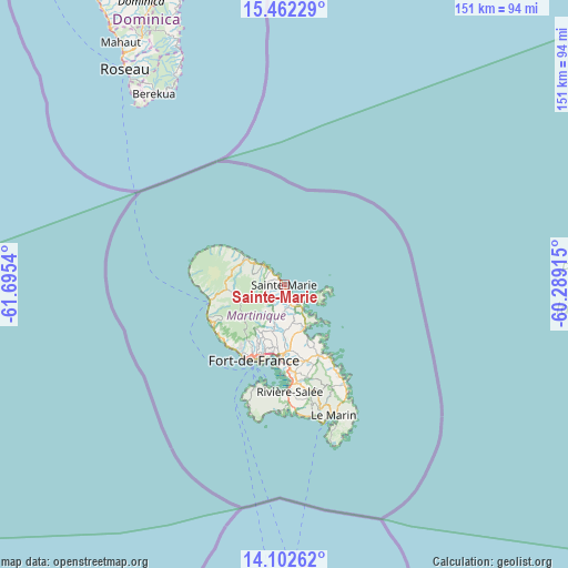
Sainte-Marie GPS coordinates[2]
14° 47' 0.672" North, 60° 59' 32.172" West
| Map corner | latitude | longitude |
|---|---|---|
| Upper-left | 15.46229°, | -61.6954° |
| Center: | 14.78352°, | -60.99227° |
| Lower-right: | 14.10262°, | -60.28915° |
| Map W x H: | 151.2×151.2 km | = 94×94mi |
| max Lat: | 14.86935° ⇑10.5% North |
| Sainte-Marie: | 14.78352° |
| min Lat: | ⇓89.5% South 14.46848° |
| min Long | Sainte-Marie | max Long |
| -61.17541° | -60.99227° | -60.83831° |
| W 52.6%⇐ | ⇒47.4% E |
Elevation
Elevation of Sainte-Marie is 14 m = 46 ft, and this is 46.8 m = 154 ft below average elevation for this country.
| Max E: |
459 m = 1506 ft | 68.4% |
| Avg. | 60.8 m = 199 ft | |
| Sainte-Marie | 14 m = 46 ft | |
Min E: |
6 m = 20 ft | 31.6% |
See also: Martinique elevation on elevation.city.
Geographical zone
Sainte-Marie is located in North Torrid zone (between Equator and Tropic of Cancer). Distance of this Northern Tropic circle is 962.1 km =597.8 mi to North.| Distance of | km | miles | from Sainte-Marie |
|---|---|---|---|
| North Pole | 8363.3 | 5196.7 | to North |
| Arctic Circle | 5757.4 | 3577.5 | to North |
| Tropic Cancer | 962.1 | 597.8 | to North |
| Equator | 1643.8 | 1021.4 | to South |


Nearby cities:
15 places around Sainte-Marie: (largest is in red/bold)
• Basse-Pointe
16.3 km =10.1 mi,  305°
305°
• Ducos
23.2 km =14.4 mi,  175°
175°
• Fort-de-France
21.9 km =13.6 mi,  203°
203°
• La Trinité
5.9 km =3.7 mi,  148°
148°
• Le François
21 km =13 mi, 152°
• Le Gros-Morne
9.3 km =5.8 mi,  185°
185°
• Le Lamentin
18.9 km =11.7 mi, 182°
• Le Lorrain
8.7 km =5.4 mi, 308°
• Le Morne-Rouge
15.4 km =9.6 mi,  266°
266°
• Le Robert
13 km =8.1 mi,  155°
155°
• Les Trois-Îlets
27.5 km =17.1 mi, 189°
• Saint-Esprit
26.7 km =16.6 mi,  166°
166°
• Saint-Joseph
13.5 km =8.4 mi, 201°
• Saint-Pierre
20.2 km =12.6 mi,  257°
257°
• Schoelcher
21.7 km =13.5 mi,  211°
211°
Sources, notices
• [Note1] Compared only with cities in Martinique existing in our database
• [Src1] Map data: © OpenStreetMap contributors (CC-BY-SA)
• [Src2] Other city data from geonames.org with taken over terms of usage.
• [Src3] Geographical zone / Annual Mean Temperature by Robert A. Rohde @ Wikipedia
