The Vale geodata
The Vale (Rivière du Rempart) is a populated place; located in Mauritius in Indian/Mauritius (GMT+4) time zone. With population of 3,707 people, there are 62 cities with bigger population in this country. Compared to other cities in Mauritius, 90.9% of cities are located further ↓South; 52.5% of cities are located further ←West and 53.5% of cities have higher elevation than The Vale. Note1


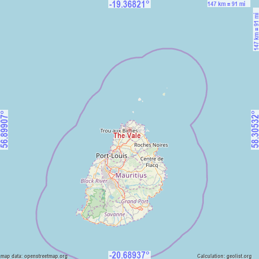
The Vale GPS coordinates[2]
20° 1' 48.648" South, 57° 36' 7.884" East
| Map corner | latitude | longitude |
|---|---|---|
| Upper-left | -19.36821°, | 56.89907° |
| Center: | -20.03018°, | 57.60219° |
| Lower-right: | -20.68937°, | 58.30532° |
| Map W x H: | 146.9×146.9 km | = 91.3×91.3mi |
| max Lat: | -10.38803° ⇑9.1% North |
| The Vale: | -20.03018° |
| min Lat: | ⇓90.9% South -20.51667° |
| min Long | The Vale | max Long |
| 56.61795° | 57.60219° | 63.41667° |
| W 52.5%⇐ | ⇒47.5% E |
Elevation
Elevation of The Vale is 93 m = 305 ft, and this is 59.1 m = 194 ft below average elevation for this country.
| Max E: |
467 m = 1532 ft | 53.5% |
| Avg. | 152.1 m = 499 ft | |
| The Vale | 93 m = 305 ft | |
Min E: |
1 m = 3 ft | 46.5% |
See also: Mauritius elevation on elevation.city.
Geographical zone
The Vale is located in South Torrid zone (between Equator and Tropic of Capricorn). Distance of this Southern Tropic circle is 378.8 km =235.4 mi to South.| Distance of | km | miles | from The Vale |
|---|---|---|---|
| Equator | 2227.1 | 1383.9 | to North |
| Tropic Capricorn | 378.8 | 235.4 | to South |
| Antarctic Circle | 5174 | 3215 | to South |
| South Pole | 7779.9 | 4834.2 | to South |


Nearby cities:
15 places around The Vale: (largest is in red/bold)
• Cap Malheureux
5.3 km =3.3 mi,  13°
13°
• Cottage
4.3 km =2.7 mi,  139°
139°
• Espérance Trébuchet
6 km =3.7 mi, 136°
• Fond du Sac
2.7 km =1.7 mi,  224°
224°
• Goodlands
5.1 km =3.2 mi,  100°
100°
• Grand Baie
2.7 km =1.7 mi,  300°
300°
• Grand Gaube
6.7 km =4.2 mi,  66°
66°
• Mapou
5.1 km =3.2 mi,  180°
180°
• Morcellement Saint André
5.8 km =3.6 mi, 217°
• Pamplemousses
8.8 km =5.5 mi,  202°
202°
• Petit Raffray
2.4 km =1.5 mi,  62°
62°
• Piton
7.3 km =4.5 mi,  156°
156°
• Plaine des Papayes
5 km =3.1 mi, 218°
• Roche Terre
4.6 km =2.9 mi, 73°
• Triolet
6.2 km =3.9 mi,  240°
240°
Sources, notices
• [Note1] Compared only with cities in Mauritius existing in our database
• [Src1] Map data: © OpenStreetMap contributors (CC-BY-SA)
• [Src2] Other city data from geonames.org with taken over terms of usage.
• [Src3] Geographical zone / Annual Mean Temperature by Robert A. Rohde @ Wikipedia
