Pamplemousses geodata
Pamplemousses is a seat of a first-order administrative division; located in Mauritius in Indian/Mauritius (GMT+4) time zone. With population of 8,836 people, there are 26 cities with bigger population in this country. Compared to other cities in Mauritius, 78.8% of cities are located further ↓South; 58.6% of cities are located further →East and 64.6% of cities have higher elevation than Pamplemousses. Note1


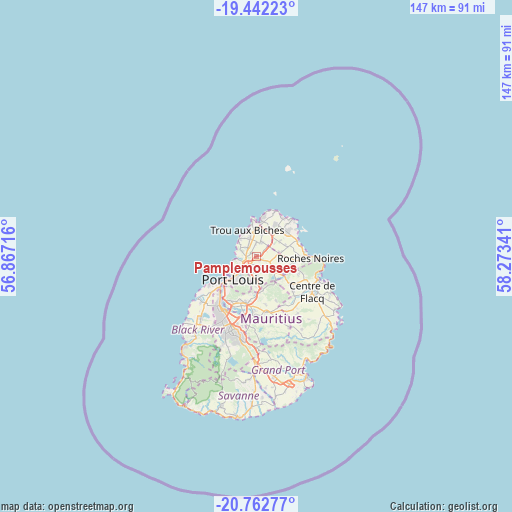
Pamplemousses GPS coordinates[2]
20° 6' 14.004" South, 57° 34' 13.008" East
| Map corner | latitude | longitude |
|---|---|---|
| Upper-left | -19.44223°, | 56.86716° |
| Center: | -20.10389°, | 57.57028° |
| Lower-right: | -20.76277°, | 58.27341° |
| Map W x H: | 146.8×146.8 km | = 91.2×91.2mi |
| max Lat: | -10.38803° ⇑21.2% North |
| Pamplemousses: | -20.10389° |
| min Lat: | ⇓78.8% South -20.51667° |
| min Long | Pamplemousses | max Long |
| 56.61795° | 57.57028° | 63.41667° |
| W 41.4%⇐ | ⇒58.6% E |
Elevation
Elevation of Pamplemousses is 64 m = 210 ft, and this is 88.1 m = 289 ft below average elevation for this country.
| Max E: |
467 m = 1532 ft | 64.6% |
| Avg. | 152.1 m = 499 ft | |
| Pamplemousses | 64 m = 210 ft | |
Min E: |
1 m = 3 ft | 35.4% |
See also: Mauritius elevation on elevation.city.
Geographical zone
Pamplemousses is located in South Torrid zone (between Equator and Tropic of Capricorn). Distance of this Southern Tropic circle is 370.6 km =230.3 mi to South.| Distance of | km | miles | from Pamplemousses |
|---|---|---|---|
| Equator | 2235.3 | 1389 | to North |
| Tropic Capricorn | 370.6 | 230.3 | to South |
| Antarctic Circle | 5165.8 | 3209.9 | to South |
| South Pole | 7771.7 | 4829.1 | to South |


Nearby cities:
15 places around Pamplemousses: (largest is in red/bold)
• Arsenal
3.7 km =2.3 mi,  267°
267°
• Calebasses
1.9 km =1.2 mi,  243°
243°
• Congomah
5.4 km =3.4 mi,  156°
156°
• Cottage
7.9 km =4.9 mi,  51°
51°
• Fond du Sac
6.5 km =4 mi,  12°
12°
• Le Hochet
6.2 km =3.9 mi, 236°
• Long Mountain
4.4 km =2.7 mi,  190°
190°
• Mapou
4.5 km =2.8 mi, 46°
• Morcellement Saint André
3.6 km =2.2 mi,  356°
356°
• Notre Dame
4.5 km =2.8 mi,  203°
203°
• Piton
6.4 km =4 mi,  76°
76°
• Plaine des Papayes
4.3 km =2.7 mi,  3°
3°
• Pointe aux Piments
6.5 km =4 mi,  311°
311°
• Terre Rouge
5.4 km =3.4 mi, 242°
• Triolet
5.6 km =3.5 mi,  337°
337°
Sources, notices
• [Note1] Compared only with cities in Mauritius existing in our database
• [Src1] Map data: © OpenStreetMap contributors (CC-BY-SA)
• [Src2] Other city data from geonames.org with taken over terms of usage.
• [Src3] Geographical zone / Annual Mean Temperature by Robert A. Rohde @ Wikipedia
