Tamarin geodata
Tamarin (Black River) is a seat of a first-order administrative division; located in Mauritius in Indian/Mauritius (GMT+4) time zone. With population of 3,764 people, there are 61 cities with bigger population in this country. Compared to other cities in Mauritius, 77.8% of cities are located further ↑North; 96% of cities are located further →East and 100% of cities have higher elevation than Tamarin. Note1


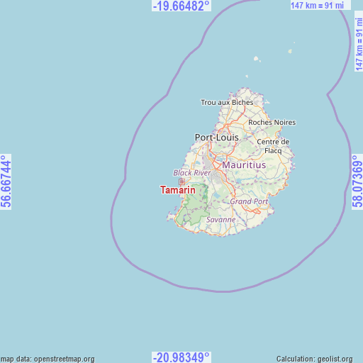
Tamarin GPS coordinates[2]
20° 19' 32.016" South, 57° 22' 14.016" East
| Map corner | latitude | longitude |
|---|---|---|
| Upper-left | -19.66482°, | 56.66744° |
| Center: | -20.32556°, | 57.37056° |
| Lower-right: | -20.98349°, | 58.07369° |
| Map W x H: | 146.6×146.6 km | = 91.1×91.1mi |
| max Lat: | -10.38803° ⇑77.8% North |
| Tamarin: | -20.32556° |
| min Lat: | ⇓22.2% South -20.51667° |
| min Long | Tamarin | max Long |
| 56.61795° | 57.37056° | 63.41667° |
| W 4%⇐ | ⇒96% E |
Elevation
Elevation of Tamarin is 1 m = 3 ft, and this is 151.1 m = 496 ft below average elevation for this country.
| Max E: |
467 m = 1532 ft | 100% |
| Avg. | 152.1 m = 499 ft | |
| Tamarin | 1 m = 3 ft | |
Min E: |
1 m = 3 ft | 0% |
See also: Mauritius elevation on elevation.city.
Geographical zone
Tamarin is located in South Torrid zone (between Equator and Tropic of Capricorn). Distance of this Southern Tropic circle is 345.9 km =214.9 mi to South.| Distance of | km | miles | from Tamarin |
|---|---|---|---|
| Equator | 2260 | 1404.3 | to North |
| Tropic Capricorn | 345.9 | 214.9 | to South |
| Antarctic Circle | 5141.2 | 3194.6 | to South |
| South Pole | 7747.1 | 4813.8 | to South |


Nearby cities:
15 places around Tamarin: (largest is in red/bold)
• Albion
13.6 km =8.5 mi,  16°
16°
• Bambous
8.5 km =5.3 mi,  25°
25°
• Beau Bassin-Rose Hill
14.3 km =8.9 mi,  44°
44°
• Cascavelle
5.7 km =3.5 mi, 41°
• Chamarel
10.9 km =6.8 mi,  172°
172°
• Curepipe
16.2 km =10.1 mi,  86°
86°
• Ebene
15.5 km =9.6 mi,  54°
54°
• Flic en Flac
5.8 km =3.6 mi,  352°
352°
• Grande Rivière Noire
3.9 km =2.4 mi,  186°
186°
• Gros Cailloux
14.5 km =9 mi, 25°
• Moka
17.6 km =10.9 mi, 47°
• Petite Case Noyale
7.5 km =4.7 mi,  184°
184°
• Petite Rivière
16.5 km =10.3 mi, 28°
• Quatre Bornes
13.2 km =8.2 mi,  58°
58°
• Vacoas
11.6 km =7.2 mi,  74°
74°
Sources, notices
• [Note1] Compared only with cities in Mauritius existing in our database
• [Src1] Map data: © OpenStreetMap contributors (CC-BY-SA)
• [Src2] Other city data from geonames.org with taken over terms of usage.
• [Src3] Geographical zone / Annual Mean Temperature by Robert A. Rohde @ Wikipedia
