El Fuerte geodata
El Fuerte (Tamaulipas) is a populated place; located in Mexico in America/Monterrey (GMT-6) time zone. With population of 638 people, there are 13580 cities with bigger population in this country. Compared to other cities in Mexico, 86.4% of cities are located further ↓South; 62.7% of cities are located further ←West and 99.3% of cities have higher elevation than El Fuerte. Note1


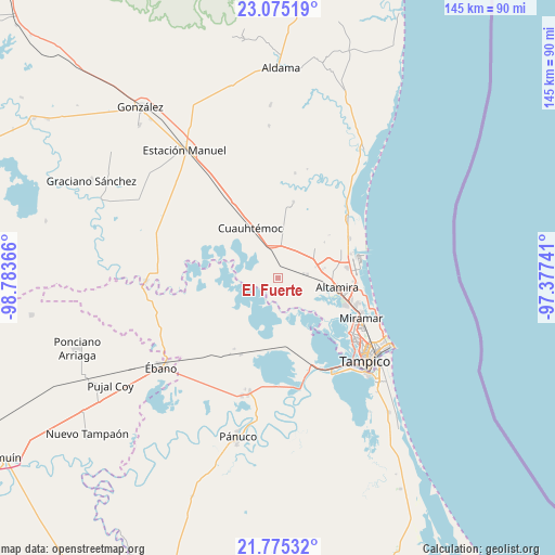
El Fuerte GPS coordinates[2]
22° 25' 36.408" North, 98° 4' 49.908" West
| Map corner | latitude | longitude |
|---|---|---|
| Upper-left | 23.07519°, | -98.78366° |
| Center: | 22.42678°, | -98.08053° |
| Lower-right: | 21.77532°, | -97.37741° |
| Map W x H: | 144.5×144.5 km | = 89.8×89.8mi |
| max Lat: | 32.7° ⇑13.6% North |
| El Fuerte: | 22.42678° |
| min Lat: | ⇓86.4% South 14.53588° |
| min Long | El Fuerte | max Long |
| -117.105° | -98.08053° | -86.73105° |
| W 62.7%⇐ | ⇒37.3% E |
Elevation
Elevation of El Fuerte is 5 m = 16 ft, and this is 1248.7 m = 4097 ft below average elevation for this country.
| Max E: |
3497 m = 11473 ft | 99.3% |
| Avg. | 1253.7 m = 4113 ft | |
| El Fuerte | 5 m = 16 ft | |
Min E: |
-1 m = -3 ft | 0.7% |
See also: Mexico elevation on elevation.city.
Geographical zone
El Fuerte is located in North Torrid zone (between Equator and Tropic of Cancer). Distance of this Northern Tropic circle is 112.3 km =69.8 mi to North.| Distance of | km | miles | from El Fuerte |
|---|---|---|---|
| North Pole | 7513.4 | 4668.6 | to North |
| Arctic Circle | 4907.5 | 3049.4 | to North |
| Tropic Cancer | 112.3 | 69.8 | to North |
| Equator | 2493.6 | 1549.5 | to South |


Nearby cities:
15 places around El Fuerte: (largest is in red/bold)
• Altamira
15.1 km =9.4 mi,  104°
104°
• Benito Juárez
9 km =5.6 mi,  38°
38°
• Carrillo Puerto
12 km =7.5 mi,  87°
87°
• Cuauhtémoc
14.9 km =9.3 mi,  331°
331°
• Esteros
11.4 km =7.1 mi,  335°
335°
• Francisco Medrano
18.8 km =11.7 mi, 86°
• José María Luis Mora
20.3 km =12.6 mi,  11°
11°
• La Colonia
6.6 km =4.1 mi,  78°
78°
• La Pedrera
20.7 km =12.9 mi, 100°
• Maclovio Herrera
8.2 km =5.1 mi,  356°
356°
• Miramar
20 km =12.4 mi,  111°
111°
• Nuevo Cereso Regional de Altamira
8.3 km =5.2 mi,  63°
63°
• Ricardo Flores Magón
18 km =11.2 mi, 81°
• Tres de Mayo
6.4 km =4 mi, 110°
• Unidos Avanzamos
11.2 km =7 mi, 85°
Sources, notices
• [Note1] Compared only with cities in Mexico existing in our database
• [Src1] Map data: © OpenStreetMap contributors (CC-BY-SA)
• [Src2] Other city data from geonames.org with taken over terms of usage.
• [Src3] Geographical zone / Annual Mean Temperature by Robert A. Rohde @ Wikipedia
