Praxedis Guerrero geodata
Praxedis Guerrero (Tamaulipas) is a populated place; located in Mexico in America/Monterrey (GMT-6) time zone. With population of 523 people, there are 16139 cities with bigger population in this country. Compared to other cities in Mexico, 87% of cities are located further ↓South; 50.5% of cities are located further →East and 75.5% of cities have higher elevation than Praxedis Guerrero. Note1


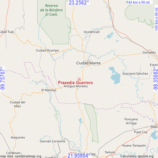
Praxedis Guerrero GPS coordinates[2]
22° 36' 31.14" North, 99° 3' 14.184" West
| Map corner | latitude | longitude |
|---|---|---|
| Upper-left | 23.2562°, | -99.75707° |
| Center: | 22.60865°, | -99.05394° |
| Lower-right: | 21.95804°, | -98.35082° |
| Map W x H: | 144.3×144.3 km | = 89.7×89.7mi |
| max Lat: | 32.7° ⇑13% North |
| Praxedis Guerrero: | 22.60865° |
| min Lat: | ⇓87% South 14.53588° |
| min Long | Praxedis Guerre | max Long |
| -117.105° | -99.05394° | -86.73105° |
| W 49.5%⇐ | ⇒50.5% E |
Elevation
Elevation of Praxedis Guerrero is 204 m = 669 ft, and this is 1049.7 m = 3444 ft below average elevation for this country.
| Max E: |
3497 m = 11473 ft | 75.5% |
| Avg. | 1253.7 m = 4113 ft | |
| Praxedis Guerrero | 204 m = 669 ft | |
Min E: |
-1 m = -3 ft | 24.5% |
See also: Mexico elevation on elevation.city.
Geographical zone
Praxedis Guerrero is located in North Torrid zone (between Equator and Tropic of Cancer). Distance of this Northern Tropic circle is 92.1 km =57.2 mi to North.| Distance of | km | miles | from Praxedis Guerrero |
|---|---|---|---|
| North Pole | 7493.2 | 4656.1 | to North |
| Arctic Circle | 4887.3 | 3036.8 | to North |
| Tropic Cancer | 92.1 | 57.2 | to North |
| Equator | 2513.8 | 1562 | to South |


Nearby cities:
15 places around Praxedis Guerrero: (largest is in red/bold)
• Adolfo López Mateos
29.8 km =18.5 mi,  331°
331°
• Antiguo Morelos
7.1 km =4.4 mi,  203°
203°
• Celaya
13.8 km =8.6 mi,  113°
113°
• Ciudad Mante
17.1 km =10.6 mi,  28°
28°
• División del Norte
30.4 km =18.9 mi,  141°
141°
• El Abra
3.6 km =2.2 mi,  68°
68°
• El Limón
24.6 km =15.3 mi,  11°
11°
• El Naranjo
29.8 km =18.5 mi,  252°
252°
• Emiliano Zapata
18.7 km =11.6 mi,  49°
49°
• Mexico Libre
11.5 km =7.1 mi,  288°
288°
• Mártires de Río Blanco
25.3 km =15.7 mi, 11°
• Nuevo Morelos
18.8 km =11.7 mi,  244°
244°
• Plan de Ayala
30.4 km =18.9 mi,  104°
104°
• Quintero
6.3 km =3.9 mi,  17°
17°
• Triunfo Número Dos
19.2 km =11.9 mi,  115°
115°
Sources, notices
• [Note1] Compared only with cities in Mexico existing in our database
• [Src1] Map data: © OpenStreetMap contributors (CC-BY-SA)
• [Src2] Other city data from geonames.org with taken over terms of usage.
• [Src3] Geographical zone / Annual Mean Temperature by Robert A. Rohde @ Wikipedia
