El Limón geodata
El Limón (Tamaulipas) is a populated place; located in Mexico in America/Monterrey (GMT-6) time zone. With population of 2,800 people, there are 3165 cities with bigger population in this country. Compared to other cities in Mexico, 87.6% of cities are located further ↓South; 50.1% of cities are located further ←West and 82.1% of cities have higher elevation than El Limón. Note1


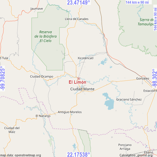
El Limón GPS coordinates[2]
22° 49' 29.928" North, 99° 0' 18.432" West
| Map corner | latitude | longitude |
|---|---|---|
| Upper-left | 23.47149°, | -99.70825° |
| Center: | 22.82498°, | -99.00512° |
| Lower-right: | 22.17538°, | -98.302° |
| Map W x H: | 144.1×144.1 km | = 89.5×89.5mi |
| max Lat: | 32.7° ⇑12.4% North |
| El Limón: | 22.82498° |
| min Lat: | ⇓87.6% South 14.53588° |
| min Long | El Limón | max Long |
| -117.105° | -99.00512° | -86.73105° |
| W 50.1%⇐ | ⇒49.9% E |
Elevation
Elevation of El Limón is 69 m = 226 ft, and this is 1184.7 m = 3887 ft below average elevation for this country.
| Max E: |
3497 m = 11473 ft | 82.1% |
| Avg. | 1253.7 m = 4113 ft | |
| El Limón | 69 m = 226 ft | |
Min E: |
-1 m = -3 ft | 17.9% |
See also: Mexico elevation on elevation.city.
Geographical zone
El Limón is located in North Torrid zone (between Equator and Tropic of Cancer). Distance of this Northern Tropic circle is 68 km =42.3 mi to North.| Distance of | km | miles | from El Limón |
|---|---|---|---|
| North Pole | 7469.2 | 4641.1 | to North |
| Arctic Circle | 4863.3 | 3021.9 | to North |
| Tropic Cancer | 68 | 42.3 | to North |
| Equator | 2537.9 | 1577 | to South |


Nearby cities:
15 places around El Limón: (largest is in red/bold)
• Adolfo López Mateos
19.4 km =12.1 mi,  276°
276°
• Ciudad Mante
9.7 km =6 mi,  160°
160°
• El Abra
22.8 km =14.2 mi,  184°
184°
• Emiliano Zapata
14.9 km =9.3 mi,  142°
142°
• Emiliano Zapata
25.5 km =15.8 mi,  29°
29°
• Gomez Farias
27.8 km =17.3 mi,  327°
327°
• Gómez Farías
6.9 km =4.3 mi,  341°
341°
• Mexico Libre
25.8 km =16 mi,  217°
217°
• Mártires de Río Blanco
0.7 km =0.4 mi,  351°
351°
• Praxedis Guerrero
24.6 km =15.3 mi,  191°
191°
• Primero de Mayo
16.1 km =10 mi,  20°
20°
• Quintero
18.3 km =11.4 mi, 189°
• Segunda Unidad Xicoténcatl
25.1 km =15.6 mi, 32°
• Venustiano Carranza Dos
28.2 km =17.5 mi,  84°
84°
• Xicoténcatl
20.1 km =12.5 mi, 18°
Sources, notices
• [Note1] Compared only with cities in Mexico existing in our database
• [Src1] Map data: © OpenStreetMap contributors (CC-BY-SA)
• [Src2] Other city data from geonames.org with taken over terms of usage.
• [Src3] Geographical zone / Annual Mean Temperature by Robert A. Rohde @ Wikipedia
