Vicente Guerrero geodata
Vicente Guerrero (Chiapas) is a populated place; located in Mexico in America/Mexico_City (GMT-6) time zone. With population of 803 people, there are 10877 cities with bigger population in this country. Compared to other cities in Mexico, 98.9% of cities are located further ↑North; 91.4% of cities are located further ←West and 81.2% of cities have higher elevation than Vicente Guerrero. Note1


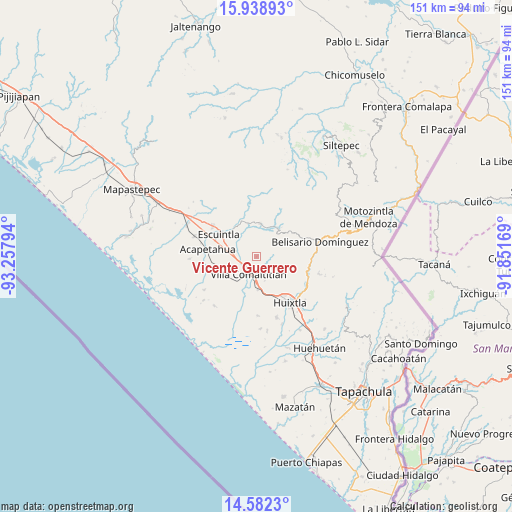
Vicente Guerrero GPS coordinates[2]
15° 15' 42.156" North, 92° 33' 17.316" West
| Map corner | latitude | longitude |
|---|---|---|
| Upper-left | 15.93893°, | -93.25794° |
| Center: | 15.26171°, | -92.55481° |
| Lower-right: | 14.5823°, | -91.85169° |
| Map W x H: | 150.8×150.8 km | = 93.7×93.7mi |
| max Lat: | 32.7° ⇑98.9% North |
| Vicente Guerrero: | 15.26171° |
| min Lat: | ⇓1.1% South 14.53588° |
| min Long | Vicente Guerrer | max Long |
| -117.105° | -92.55481° | -86.73105° |
| W 91.4%⇐ | ⇒8.6% E |
Elevation
Elevation of Vicente Guerrero is 79 m = 259 ft, and this is 1174.7 m = 3854 ft below average elevation for this country.
| Max E: |
3497 m = 11473 ft | 81.2% |
| Avg. | 1253.7 m = 4113 ft | |
| Vicente Guerrero | 79 m = 259 ft | |
Min E: |
-1 m = -3 ft | 18.8% |
See also: Mexico elevation on elevation.city.
Geographical zone
Vicente Guerrero is located in North Torrid zone (between Equator and Tropic of Cancer). Distance of this Northern Tropic circle is 909 km =564.8 mi to North.| Distance of | km | miles | from Vicente Guerrero |
|---|---|---|---|
| North Pole | 8310.1 | 5163.7 | to North |
| Arctic Circle | 5704.2 | 3544.4 | to North |
| Tropic Cancer | 909 | 564.8 | to North |
| Equator | 1696.9 | 1054.4 | to South |


Nearby cities:
15 places around Vicente Guerrero: (largest is in red/bold)
• Cantón Santa Cruz la Unión
9.6 km =6 mi,  206°
206°
• Cintalapa
10.7 km =6.6 mi,  322°
322°
• El Triunfo
9.9 km =6.2 mi,  5°
5°
• Escuintla
12.8 km =8 mi,  300°
300°
• Hidalgo
13.7 km =8.5 mi,  216°
216°
• La Independencia
10.1 km =6.3 mi,  345°
345°
• Lázaro Cárdenas
9.8 km =6.1 mi,  178°
178°
• Monte Flor Arriba
6.8 km =4.2 mi,  344°
344°
• Nueva América
12.2 km =7.6 mi,  78°
78°
• Nuevo Brasil
7.5 km =4.7 mi,  162°
162°
• San Felipe Tizapa
6.4 km =4 mi,  284°
284°
• Teziutlán
12.8 km =8 mi,  233°
233°
• Unión Jamaica
9.1 km =5.7 mi,  20°
20°
• Villa Comaltitlán
5.8 km =3.6 mi,  203°
203°
• Zacualpa
13 km =8.1 mi, 216°
Sources, notices
• [Note1] Compared only with cities in Mexico existing in our database
• [Src1] Map data: © OpenStreetMap contributors (CC-BY-SA)
• [Src2] Other city data from geonames.org with taken over terms of usage.
• [Src3] Geographical zone / Annual Mean Temperature by Robert A. Rohde @ Wikipedia
