Tres Zapotes geodata
Tres Zapotes (Veracruz) is a populated place; located in Mexico in America/Mexico_City (GMT-6) time zone. With population of 3,464 people, there are 2636 cities with bigger population in this country. Compared to other cities in Mexico, 73% of cities are located further ↑North; 83.2% of cities are located further ←West and 88.3% of cities have higher elevation than Tres Zapotes. Note1


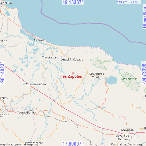
Tres Zapotes GPS coordinates[2]
18° 28' 5.772" North, 95° 26' 13.56" West
| Map corner | latitude | longitude |
|---|---|---|
| Upper-left | 19.13387°, | -96.14023° |
| Center: | 18.46827°, | -95.4371° |
| Lower-right: | 17.80007°, | -94.73398° |
| Map W x H: | 148.3×148.3 km | = 92.1×92.1mi |
| max Lat: | 32.7° ⇑73% North |
| Tres Zapotes: | 18.46827° |
| min Lat: | ⇓27% South 14.53588° |
| min Long | Tres Zapotes | max Long |
| -117.105° | -95.4371° | -86.73105° |
| W 83.2%⇐ | ⇒16.8% E |
Elevation
Elevation of Tres Zapotes is 29 m = 95 ft, and this is 1224.7 m = 4018 ft below average elevation for this country.
| Max E: |
3497 m = 11473 ft | 88.3% |
| Avg. | 1253.7 m = 4113 ft | |
| Tres Zapotes | 29 m = 95 ft | |
Min E: |
-1 m = -3 ft | 11.7% |
See also: Mexico elevation on elevation.city.
Geographical zone
Tres Zapotes is located in North Torrid zone (between Equator and Tropic of Cancer). Distance of this Northern Tropic circle is 552.4 km =343.2 mi to North.| Distance of | km | miles | from Tres Zapotes |
|---|---|---|---|
| North Pole | 7953.6 | 4942.1 | to North |
| Arctic Circle | 5347.7 | 3322.9 | to North |
| Tropic Cancer | 552.4 | 343.2 | to North |
| Equator | 2053.5 | 1276 | to South |


Nearby cities:
15 places around Tres Zapotes: (largest is in red/bold)
• Arroyo Largo
6.5 km =4 mi,  159°
159°
• Arroyo San Isidro
3.2 km =2 mi,  50°
50°
• Boca del Monte
11.2 km =7 mi,  144°
144°
• Chonegal
12.8 km =8 mi,  21°
21°
• El Escobillal
12.5 km =7.8 mi,  5°
5°
• La Providencia
6.2 km =3.9 mi,  321°
321°
• Los Lirios
6.3 km =3.9 mi,  55°
55°
• Medellín
9.5 km =5.9 mi,  127°
127°
• Ojo de Agua
12.8 km =8 mi,  145°
145°
• San Antonio de la Huerta
10 km =6.2 mi,  176°
176°
• San Juan de los Reyes (Luis Valenzuela)
5.6 km =3.5 mi,  347°
347°
• Sehualaca
12.9 km =8 mi,  111°
111°
• Tlapacoyan
4.1 km =2.5 mi, 108°
• Vista Hermosa
13.2 km =8.2 mi, 110°
• Zamora
13.5 km =8.4 mi,  338°
338°
Sources, notices
• [Note1] Compared only with cities in Mexico existing in our database
• [Src1] Map data: © OpenStreetMap contributors (CC-BY-SA)
• [Src2] Other city data from geonames.org with taken over terms of usage.
• [Src3] Geographical zone / Annual Mean Temperature by Robert A. Rohde @ Wikipedia
