Tila geodata
Tila (Chiapas) is a seat of a second-order administrative division; located in Mexico in America/Mexico_City (GMT-6) time zone. With population of 7,164 people, there are 1295 cities with bigger population in this country. Compared to other cities in Mexico, 85.2% of cities are located further ↑North; 92.5% of cities are located further ←West and 59.3% of cities have higher elevation than Tila. Note1


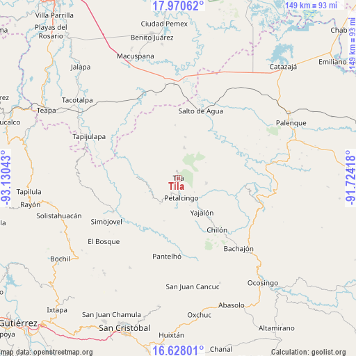
Tila GPS coordinates[2]
17° 18' 1.944" North, 92° 25' 38.28" West
| Map corner | latitude | longitude |
|---|---|---|
| Upper-left | 17.97062°, | -93.13043° |
| Center: | 17.30054°, | -92.4273° |
| Lower-right: | 16.62801°, | -91.72418° |
| Map W x H: | 149.3×149.3 km | = 92.8×92.8mi |
| max Lat: | 32.7° ⇑85.2% North |
| Tila: | 17.30054° |
| min Lat: | ⇓14.8% South 14.53588° |
| min Long | Tila | max Long |
| -117.105° | -92.4273° | -86.73105° |
| W 92.5%⇐ | ⇒7.5% E |
Elevation
Elevation of Tila is 1035 m = 3396 ft, and this is 218.7 m = 718 ft below average elevation for this country.
| Max E: |
3497 m = 11473 ft | 59.3% |
| Avg. | 1253.7 m = 4113 ft | |
| Tila | 1035 m = 3396 ft | |
Min E: |
-1 m = -3 ft | 40.7% |
See also: Mexico elevation on elevation.city.
Geographical zone
Tila is located in North Torrid zone (between Equator and Tropic of Cancer). Distance of this Northern Tropic circle is 682.3 km =424 mi to North.| Distance of | km | miles | from Tila |
|---|---|---|---|
| North Pole | 8083.4 | 5022.8 | to North |
| Arctic Circle | 5477.5 | 3403.6 | to North |
| Tropic Cancer | 682.3 | 424 | to North |
| Equator | 1923.6 | 1195.3 | to South |


Nearby cities:
15 places around Tila: (largest is in red/bold)
• Cantioc
4.8 km =3 mi,  153°
153°
• Chilón
7.6 km =4.7 mi,  171°
171°
• Coquija
6.6 km =4.1 mi,  250°
250°
• El Carrizal
5.5 km =3.4 mi,  8°
8°
• El Ocotal
8.4 km =5.2 mi,  255°
255°
• Jolpokitioc
3.9 km =2.4 mi,  218°
218°
• Jolsibaquil
7.3 km =4.5 mi,  231°
231°
• Mariscal Subikuski
6.1 km =3.8 mi,  54°
54°
• Misija
6.2 km =3.9 mi,  128°
128°
• Nueva Esperanza
6.6 km =4.1 mi,  206°
206°
• Petalcingo
8.3 km =5.2 mi, 170°
• Río Grande
4.2 km =2.6 mi,  164°
164°
• Tiontiepa Benito Juárez
5.3 km =3.3 mi,  267°
267°
• Unión Juárez
3.7 km =2.3 mi, 126°
• Yok Pokitiok
5 km =3.1 mi,  200°
200°
Sources, notices
• [Note1] Compared only with cities in Mexico existing in our database
• [Src1] Map data: © OpenStreetMap contributors (CC-BY-SA)
• [Src2] Other city data from geonames.org with taken over terms of usage.
• [Src3] Geographical zone / Annual Mean Temperature by Robert A. Rohde @ Wikipedia
