El Carrizal geodata
El Carrizal (Chiapas) is a populated place; located in Mexico in America/Mexico_City (GMT-6) time zone. With population of 883 people, there are 9888 cities with bigger population in this country. Compared to other cities in Mexico, 84.7% of cities are located further ↑North; 92.6% of cities are located further ←West and 57.6% of cities have higher elevation than El Carrizal. Note1


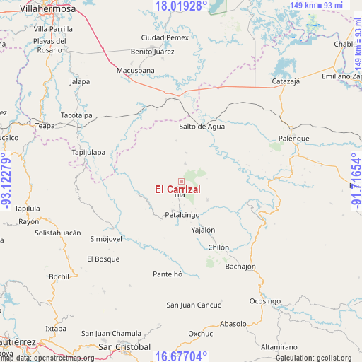
El Carrizal GPS coordinates[2]
17° 20' 57.804" North, 92° 25' 10.776" West
| Map corner | latitude | longitude |
|---|---|---|
| Upper-left | 18.01928°, | -93.12279° |
| Center: | 17.34939°, | -92.41966° |
| Lower-right: | 16.67704°, | -91.71654° |
| Map W x H: | 149.2×149.2 km | = 92.7×92.7mi |
| max Lat: | 32.7° ⇑84.7% North |
| El Carrizal: | 17.34939° |
| min Lat: | ⇓15.3% South 14.53588° |
| min Long | El Carrizal | max Long |
| -117.105° | -92.41966° | -86.73105° |
| W 92.6%⇐ | ⇒7.4% E |
Elevation
Elevation of El Carrizal is 1111 m = 3645 ft, and this is 142.7 m = 468 ft below average elevation for this country.
| Max E: |
3497 m = 11473 ft | 57.6% |
| Avg. | 1253.7 m = 4113 ft | |
| El Carrizal | 1111 m = 3645 ft | |
Min E: |
-1 m = -3 ft | 42.4% |
See also: Mexico elevation on elevation.city.
Geographical zone
El Carrizal is located in North Torrid zone (between Equator and Tropic of Cancer). Distance of this Northern Tropic circle is 676.8 km =420.5 mi to North.| Distance of | km | miles | from El Carrizal |
|---|---|---|---|
| North Pole | 8078 | 5019.4 | to North |
| Arctic Circle | 5472.1 | 3400.2 | to North |
| Tropic Cancer | 676.8 | 420.5 | to North |
| Equator | 1929.1 | 1198.7 | to South |


Nearby cities:
15 places around El Carrizal: (largest is in red/bold)
• Cantioc
9.8 km =6.1 mi,  172°
172°
• Coquija
10.3 km =6.4 mi,  222°
222°
• El Crucero
5.1 km =3.2 mi,  295°
295°
• El Limar
7.5 km =4.7 mi,  13°
13°
• El Progreso
8.4 km =5.2 mi,  37°
37°
• Jolpokitioc
9.1 km =5.7 mi,  200°
200°
• La Esperanza del Porvenir
8.4 km =5.2 mi,  79°
79°
• Mariscal Subikuski
4.5 km =2.8 mi,  114°
114°
• Mariscal Yehuitz
5.9 km =3.7 mi,  89°
89°
• Misija
10.1 km =6.3 mi,  156°
156°
• Río Grande
9.5 km =5.9 mi,  178°
178°
• Tila
5.5 km =3.4 mi,  188°
188°
• Tiontiepa Benito Juárez
8.4 km =5.2 mi,  227°
227°
• Tza'Quil
8.1 km =5 mi,  314°
314°
• Unión Juárez
7.9 km =4.9 mi, 164°
Sources, notices
• [Note1] Compared only with cities in Mexico existing in our database
• [Src1] Map data: © OpenStreetMap contributors (CC-BY-SA)
• [Src2] Other city data from geonames.org with taken over terms of usage.
• [Src3] Geographical zone / Annual Mean Temperature by Robert A. Rohde @ Wikipedia
