Tezoatlán de Segura y Luna geodata
Tezoatlán de Segura y Luna (Oaxaca) is a seat of a second-order administrative division; located in Mexico in America/Mexico_City (GMT-6) time zone. In our database, there are 16903 cities with bigger population. Compared to other cities in Mexico, 81.7% of cities are located further ↑North; 65.9% of cities are located further ←West and 51.9% of cities have lower elevation than Tezoatlán de Segura y Luna. Note1
Administrative division(s):
- Level 1: Oaxaca
- Level 2: Heroica Villa Tezoatlán de Segura y Luna, Cuna de la Independencia de Oaxaca
Current local time in Tezoatlán de Segura y Luna:
08:44 AM, MondayDifference from your time zone: hours


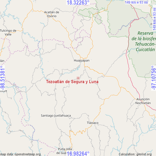
Tezoatlán de Segura y Luna GPS coordinates[2]
17° 39' 13.968" North, 97° 48' 38.448" West
| Map corner | latitude | longitude |
|---|---|---|
| Upper-left | 18.32263°, | -98.51381° |
| Center: | 17.65388°, | -97.81068° |
| Lower-right: | 16.98264°, | -97.10756° |
| Map W x H: | 149×149 km | = 92.6×92.6mi |
| max Lat: | 32.7° ⇑81.7% North |
| Tezoatlán de Segura y Luna: | 17.65388° |
| min Lat: | ⇓18.3% South 14.53588° |
| min Long | Tezoatlán de S | max Long |
| -117.105° | -97.81068° | -86.73105° |
| W 65.9%⇐ | ⇒34.1% E |
Elevation
Elevation of Tezoatlán de Segura y Luna is 1522 m = 4993 ft, and this is 268.3 m = 880 ft above average elevation for this country.
| Max E: |
3497 m = 11473 ft | 48.1% |
| Tezoatlán de Segura y Luna | 1522 m 4993 ft | |
| Avg. | 1253.7 m = 4113 ft | |
Min E: |
-1 m = -3 ft | 51.9% |
See also: Mexico elevation on elevation.city.
Geographical zone
Tezoatlán de Segura y Luna is located in North Torrid zone (between Equator and Tropic of Cancer). Distance of this Northern Tropic circle is 643 km =399.5 mi to North.| Distance of | km | miles | from Tezoatlán de Segura y Luna |
|---|---|---|---|
| North Pole | 8044.1 | 4998.4 | to North |
| Arctic Circle | 5438.2 | 3379.1 | to North |
| Tropic Cancer | 643 | 399.5 | to North |
| Equator | 1962.9 | 1219.7 | to South |


Nearby cities:
15 places around Tezoatlán de Segura y Luna: (largest is in red/bold)
• Corral de Piedra
13.4 km =8.3 mi,  35°
35°
• El Molino
14.9 km =9.3 mi,  24°
24°
• La Estancia
15.9 km =9.9 mi,  14°
14°
• Los Naranjos [Fraccionamiento]
15.1 km =9.4 mi, 13°
• San Andrés Dinicuiti
9.7 km =6 mi,  66°
66°
• San Andrés Yutatío
10.2 km =6.3 mi,  239°
239°
• San Antonio de León
9.4 km =5.8 mi,  59°
59°
• San Francisco Yosocuta
10.3 km =6.4 mi,  355°
355°
• San Juan Diquiyu
9.4 km =5.8 mi,  200°
200°
• San Marcos Arteaga
9.3 km =5.8 mi,  325°
325°
• San Miguel Monteverde
13.8 km =8.6 mi,  171°
171°
• Santiago Cacaloxtepec
10.6 km =6.6 mi, 44°
• Santo Domingo Yodohino
14.2 km =8.8 mi,  106°
106°
• Saucitlán de Morelos
14.4 km =8.9 mi,  349°
349°
• Yucuñuti de Benito Juárez
8.7 km =5.4 mi,  256°
256°
Sources, notices
• [Note1] Compared only with cities in Mexico existing in our database
• [Src1] Map data: © OpenStreetMap contributors (CC-BY-SA)
• [Src2] Other city data from geonames.org with taken over terms of usage.
• [Src3] Geographical zone / Annual Mean Temperature by Robert A. Rohde @ Wikipedia
