Corral de Piedra geodata
Corral de Piedra (Oaxaca) is a populated place; located in Mexico in America/Mexico_City (GMT-6) time zone. With population of 692 people, there are 12576 cities with bigger population in this country. Compared to other cities in Mexico, 80.9% of cities are located further ↑North; 66.8% of cities are located further ←West and 66.6% of cities have lower elevation than Corral de Piedra. Note1


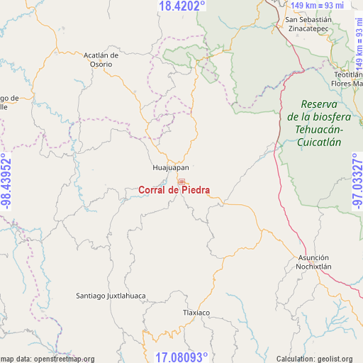
Corral de Piedra GPS coordinates[2]
17° 45' 6.552" North, 97° 44' 11.004" West
| Map corner | latitude | longitude |
|---|---|---|
| Upper-left | 18.4202°, | -98.43952° |
| Center: | 17.75182°, | -97.73639° |
| Lower-right: | 17.08093°, | -97.03327° |
| Map W x H: | 148.9×148.9 km | = 92.5×92.5mi |
| max Lat: | 32.7° ⇑80.9% North |
| Corral de Piedra: | 17.75182° |
| min Lat: | ⇓19.1% South 14.53588° |
| min Long | Corral de Piedr | max Long |
| -117.105° | -97.73639° | -86.73105° |
| W 66.8%⇐ | ⇒33.2% E |
Elevation
Elevation of Corral de Piedra is 1862 m = 6109 ft, and this is 608.3 m = 1996 ft above average elevation for this country.
| Max E: |
3497 m = 11473 ft | 33.4% |
| Corral de Piedra | 1862 m 6109 ft | |
| Avg. | 1253.7 m = 4113 ft | |
Min E: |
-1 m = -3 ft | 66.6% |
See also: Mexico elevation on elevation.city.
Geographical zone
Corral de Piedra is located in North Torrid zone (between Equator and Tropic of Cancer). Distance of this Northern Tropic circle is 632.1 km =392.8 mi to North.| Distance of | km | miles | from Corral de Piedra |
|---|---|---|---|
| North Pole | 8033.2 | 4991.6 | to North |
| Arctic Circle | 5427.4 | 3372.4 | to North |
| Tropic Cancer | 632.1 | 392.8 | to North |
| Equator | 1973.8 | 1226.5 | to South |


Nearby cities:
15 places around Corral de Piedra: (largest is in red/bold)
• Acatilma
11.4 km =7.1 mi,  317°
317°
• Ciudad de Huajuapan de León
7.7 km =4.8 mi, 323°
• Colonia Buena Vista
11.7 km =7.3 mi,  313°
313°
• El Molino
3.1 km =1.9 mi,  327°
327°
• La Estancia
6.1 km =3.8 mi, 318°
• La Junta
8.5 km =5.3 mi,  353°
353°
• Los Naranjos [Fraccionamiento]
5.7 km =3.5 mi, 311°
• San Andrés Dinicuiti
7.2 km =4.5 mi,  171°
171°
• San Antonio de León
6.1 km =3.8 mi,  178°
178°
• San Francisco Yosocuta
8.7 km =5.4 mi,  265°
265°
• San Sebastián Progreso
8.2 km =5.1 mi,  35°
35°
• Santiago Cacaloxtepec
3.4 km =2.1 mi,  187°
187°
• Santiago Huajolotitlán
8.5 km =5.3 mi,  2°
2°
• Saucitlán de Morelos
11 km =6.8 mi,  287°
287°
• Vista Hermosa
5.4 km =3.4 mi,  336°
336°
Sources, notices
• [Note1] Compared only with cities in Mexico existing in our database
• [Src1] Map data: © OpenStreetMap contributors (CC-BY-SA)
• [Src2] Other city data from geonames.org with taken over terms of usage.
• [Src3] Geographical zone / Annual Mean Temperature by Robert A. Rohde @ Wikipedia
