La Estancia geodata
La Estancia (Oaxaca) is a populated place; located in Mexico in America/Mexico_City (GMT-6) time zone. With population of 519 people, there are 16226 cities with bigger population in this country. Compared to other cities in Mexico, 80.6% of cities are located further ↑North; 66.4% of cities are located further ←West and 55% of cities have lower elevation than La Estancia. Note1


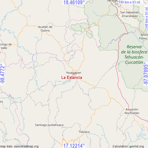
La Estancia GPS coordinates[2]
17° 47' 34.332" North, 97° 46' 26.652" West
| Map corner | latitude | longitude |
|---|---|---|
| Upper-left | 18.46109°, | -98.4772° |
| Center: | 17.79287°, | -97.77407° |
| Lower-right: | 17.12214°, | -97.07095° |
| Map W x H: | 148.9×148.9 km | = 92.5×92.5mi |
| max Lat: | 32.7° ⇑80.6% North |
| La Estancia: | 17.79287° |
| min Lat: | ⇓19.4% South 14.53588° |
| min Long | La Estancia | max Long |
| -117.105° | -97.77407° | -86.73105° |
| W 66.4%⇐ | ⇒33.6% E |
Elevation
Elevation of La Estancia is 1589 m = 5213 ft, and this is 335.3 m = 1100 ft above average elevation for this country.
| Max E: |
3497 m = 11473 ft | 45% |
| La Estancia | 1589 m 5213 ft | |
| Avg. | 1253.7 m = 4113 ft | |
Min E: |
-1 m = -3 ft | 55% |
See also: Mexico elevation on elevation.city.
Geographical zone
La Estancia is located in North Torrid zone (between Equator and Tropic of Cancer). Distance of this Northern Tropic circle is 627.5 km =389.9 mi to North.| Distance of | km | miles | from La Estancia |
|---|---|---|---|
| North Pole | 8028.7 | 4988.8 | to North |
| Arctic Circle | 5422.8 | 3369.6 | to North |
| Tropic Cancer | 627.5 | 389.9 | to North |
| Equator | 1978.4 | 1229.3 | to South |


Nearby cities:
15 places around La Estancia: (largest is in red/bold)
• Acatilma
5.4 km =3.4 mi,  314°
314°
• Ciudad de Huajuapan de León
1.8 km =1.1 mi,  340°
340°
• Colonia Buena Vista
5.6 km =3.5 mi, 308°
• Corral de Piedra
6.1 km =3.8 mi,  138°
138°
• El Molino
3 km =1.9 mi,  130°
130°
• La Junta
4.9 km =3 mi,  37°
37°
• Los Naranjos [Fraccionamiento]
0.9 km =0.6 mi,  198°
198°
• San Antonio de León
11.5 km =7.1 mi,  158°
158°
• San Francisco Yosocuta
7 km =4.3 mi,  222°
222°
• San Jerónimo Silacayoapilla
7.7 km =4.8 mi,  284°
284°
• San Sebastián Progreso
9 km =5.6 mi,  76°
76°
• Santiago Cacaloxtepec
8.7 km =5.4 mi, 155°
• Santiago Huajolotitlán
5.9 km =3.7 mi,  48°
48°
• Saucitlán de Morelos
6.6 km =4.1 mi,  259°
259°
• Vista Hermosa
1.9 km =1.2 mi, 77°
Sources, notices
• [Note1] Compared only with cities in Mexico existing in our database
• [Src1] Map data: © OpenStreetMap contributors (CC-BY-SA)
• [Src2] Other city data from geonames.org with taken over terms of usage.
• [Src3] Geographical zone / Annual Mean Temperature by Robert A. Rohde @ Wikipedia
