Tetecala geodata
Tetecala (Morelos) is a seat of a second-order administrative division; located in Mexico in America/Mexico_City (GMT-6) time zone. With population of 4,893 people, there are 1889 cities with bigger population in this country. Compared to other cities in Mexico, 69.8% of cities are located further ↑North; 55.6% of cities are located further →East and 60.3% of cities have higher elevation than Tetecala. Note1


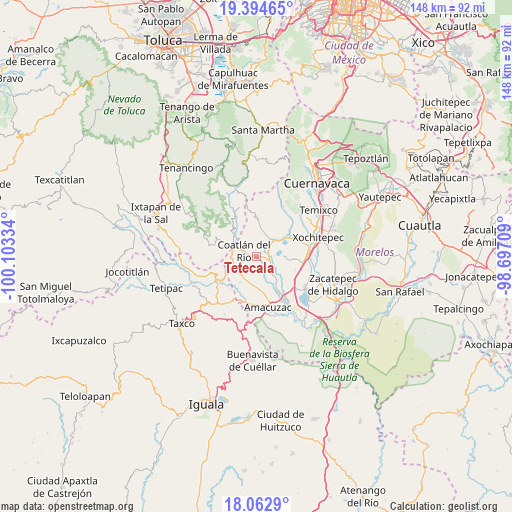
Tetecala GPS coordinates[2]
18° 43' 48.324" North, 99° 24' 0.756" West
| Map corner | latitude | longitude |
|---|---|---|
| Upper-left | 19.39465°, | -100.10334° |
| Center: | 18.73009°, | -99.40021° |
| Lower-right: | 18.0629°, | -98.69709° |
| Map W x H: | 148.1×148.1 km | = 92×92mi |
| max Lat: | 32.7° ⇑69.8% North |
| Tetecala: | 18.73009° |
| min Lat: | ⇓30.2% South 14.53588° |
| min Long | Tetecala | max Long |
| -117.105° | -99.40021° | -86.73105° |
| W 44.4%⇐ | ⇒55.6% E |
Elevation
Elevation of Tetecala is 986 m = 3235 ft, and this is 267.7 m = 878 ft below average elevation for this country.
| Max E: |
3497 m = 11473 ft | 60.3% |
| Avg. | 1253.7 m = 4113 ft | |
| Tetecala | 986 m = 3235 ft | |
Min E: |
-1 m = -3 ft | 39.7% |
See also: Mexico elevation on elevation.city.
Geographical zone
Tetecala is located in North Torrid zone (between Equator and Tropic of Cancer). Distance of this Northern Tropic circle is 523.3 km =325.2 mi to North.| Distance of | km | miles | from Tetecala |
|---|---|---|---|
| North Pole | 7924.5 | 4924.1 | to North |
| Arctic Circle | 5318.6 | 3304.8 | to North |
| Tropic Cancer | 523.3 | 325.2 | to North |
| Equator | 2082.6 | 1294.1 | to South |


Nearby cities:
15 places around Tetecala: (largest is in red/bold)
• Chavarría
7.2 km =4.5 mi,  266°
266°
• Coatetelco
7.8 km =4.8 mi,  90°
90°
• Coatlán del Río
3.8 km =2.4 mi,  294°
294°
• Cocoyotla
6 km =3.7 mi,  296°
296°
• Colonia Cuauhtémoc
5.3 km =3.3 mi, 297°
• Colonia Morelos
7.6 km =4.7 mi, 301°
• Colonia Sonora
1.4 km =0.9 mi, 295°
• Colonia Vista Hermosa
5.8 km =3.6 mi,  58°
58°
• Colonia el Florido
3.6 km =2.2 mi,  75°
75°
• Cuauchichinola
7.8 km =4.8 mi,  160°
160°
• El Mirador
7.7 km =4.8 mi,  53°
53°
• Mazatepec
3.9 km =2.4 mi, 93°
• Miacatlán
5.6 km =3.5 mi, 50°
• Santa Cruz Vista Alegre
2 km =1.2 mi, 91°
• Tilancingo
5.7 km =3.5 mi,  278°
278°
Sources, notices
• [Note1] Compared only with cities in Mexico existing in our database
• [Src1] Map data: © OpenStreetMap contributors (CC-BY-SA)
• [Src2] Other city data from geonames.org with taken over terms of usage.
• [Src3] Geographical zone / Annual Mean Temperature by Robert A. Rohde @ Wikipedia
