Coatetelco geodata
Coatetelco (Morelos) is a populated place; located in Mexico in America/Mexico_City (GMT-6) time zone. With population of 9,094 people, there are 1038 cities with bigger population in this country. Compared to other cities in Mexico, 69.9% of cities are located further ↑North; 54.5% of cities are located further →East and 60.2% of cities have higher elevation than Coatetelco. Note1


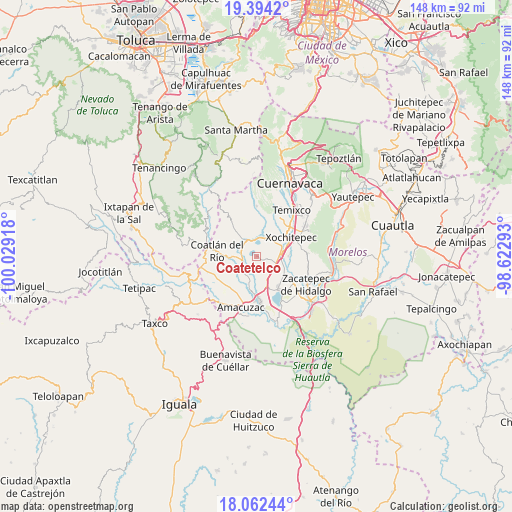
Coatetelco GPS coordinates[2]
18° 43' 46.668" North, 99° 19' 33.78" West
| Map corner | latitude | longitude |
|---|---|---|
| Upper-left | 19.3942°, | -100.02918° |
| Center: | 18.72963°, | -99.32605° |
| Lower-right: | 18.06244°, | -98.62293° |
| Map W x H: | 148.1×148.1 km | = 92×92mi |
| max Lat: | 32.7° ⇑69.9% North |
| Coatetelco: | 18.72963° |
| min Lat: | ⇓30.1% South 14.53588° |
| min Long | Coatetelco | max Long |
| -117.105° | -99.32605° | -86.73105° |
| W 45.5%⇐ | ⇒54.5% E |
Elevation
Elevation of Coatetelco is 989 m = 3245 ft, and this is 264.7 m = 868 ft below average elevation for this country.
| Max E: |
3497 m = 11473 ft | 60.2% |
| Avg. | 1253.7 m = 4113 ft | |
| Coatetelco | 989 m = 3245 ft | |
Min E: |
-1 m = -3 ft | 39.8% |
See also: Mexico elevation on elevation.city.
Geographical zone
Coatetelco is located in North Torrid zone (between Equator and Tropic of Cancer). Distance of this Northern Tropic circle is 523.4 km =325.2 mi to North.| Distance of | km | miles | from Coatetelco |
|---|---|---|---|
| North Pole | 7924.5 | 4924.1 | to North |
| Arctic Circle | 5318.6 | 3304.8 | to North |
| Tropic Cancer | 523.4 | 325.2 | to North |
| Equator | 2082.5 | 1294 | to South |


Nearby cities:
15 places around Coatetelco: (largest is in red/bold)
• Ahuehuetzingo
5.8 km =3.6 mi,  161°
161°
• Alpuyeca
7.1 km =4.4 mi,  80°
80°
• Colonia Ampliación 3 de Mayo
8.1 km =5 mi, 78°
• Colonia Sonora
9.1 km =5.7 mi,  273°
273°
• Colonia Vista Hermosa
4.2 km =2.6 mi,  316°
316°
• Colonia el Florido
4.4 km =2.7 mi,  282°
282°
• Colonia la Pintora
7.3 km =4.5 mi,  97°
97°
• Cuauchichinola
9 km =5.6 mi,  215°
215°
• El Mirador
4.9 km =3 mi,  340°
340°
• El Rodeo
5.5 km =3.4 mi,  3°
3°
• Mazatepec
3.9 km =2.4 mi, 267°
• Miacatlán
5 km =3.1 mi, 315°
• Santa Cruz Vista Alegre
5.9 km =3.7 mi, 270°
• Tetecala
7.8 km =4.8 mi, 270°
• Xochicalco (Cirenio Longares)
7 km =4.3 mi,  23°
23°
Sources, notices
• [Note1] Compared only with cities in Mexico existing in our database
• [Src1] Map data: © OpenStreetMap contributors (CC-BY-SA)
• [Src2] Other city data from geonames.org with taken over terms of usage.
• [Src3] Geographical zone / Annual Mean Temperature by Robert A. Rohde @ Wikipedia
