Cocoyotla geodata
Cocoyotla (Morelos) is a populated place; located in Mexico in America/Mexico_City (GMT-6) time zone. With population of 1,376 people, there are 6307 cities with bigger population in this country. Compared to other cities in Mexico, 69.4% of cities are located further ↑North; 56.2% of cities are located further →East and 59.1% of cities have higher elevation than Cocoyotla. Note1


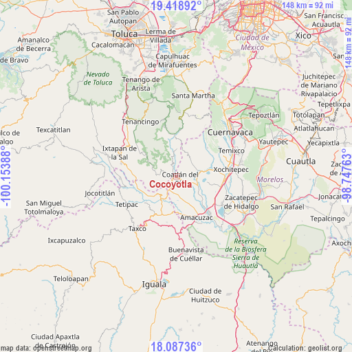
Cocoyotla GPS coordinates[2]
18° 45' 16.02" North, 99° 27' 2.7" West
| Map corner | latitude | longitude |
|---|---|---|
| Upper-left | 19.41892°, | -100.15388° |
| Center: | 18.75445°, | -99.45075° |
| Lower-right: | 18.08736°, | -98.74763° |
| Map W x H: | 148.1×148.1 km | = 92×92mi |
| max Lat: | 32.7° ⇑69.4% North |
| Cocoyotla: | 18.75445° |
| min Lat: | ⇓30.6% South 14.53588° |
| min Long | Cocoyotla | max Long |
| -117.105° | -99.45075° | -86.73105° |
| W 43.8%⇐ | ⇒56.2% E |
Elevation
Elevation of Cocoyotla is 1049 m = 3442 ft, and this is 204.7 m = 672 ft below average elevation for this country.
| Max E: |
3497 m = 11473 ft | 59.1% |
| Avg. | 1253.7 m = 4113 ft | |
| Cocoyotla | 1049 m = 3442 ft | |
Min E: |
-1 m = -3 ft | 40.9% |
See also: Mexico elevation on elevation.city.
Geographical zone
Cocoyotla is located in North Torrid zone (between Equator and Tropic of Cancer). Distance of this Northern Tropic circle is 520.6 km =323.5 mi to North.| Distance of | km | miles | from Cocoyotla |
|---|---|---|---|
| North Pole | 7921.8 | 4922.4 | to North |
| Arctic Circle | 5315.9 | 3303.1 | to North |
| Tropic Cancer | 520.6 | 323.5 | to North |
| Equator | 2085.3 | 1295.7 | to South |


Nearby cities:
15 places around Cocoyotla: (largest is in red/bold)
• Apancingo
8.4 km =5.2 mi,  189°
189°
• Chavarría
3.7 km =2.3 mi,  210°
210°
• Coatlán del Río
2.2 km =1.4 mi,  121°
121°
• Colonia Cuauhtémoc
0.6 km =0.4 mi,  113°
113°
• Colonia Guadalupe Victoria
2.7 km =1.7 mi,  283°
283°
• Colonia Juárez
5.4 km =3.4 mi,  352°
352°
• Colonia Morelos
1.7 km =1.1 mi,  315°
315°
• Colonia Sonora
4.6 km =2.9 mi, 117°
• El Platanar
8.4 km =5.2 mi,  355°
355°
• Michapa
6.5 km =4 mi, 207°
• Noxtepec de Zaragoza (El Aguacate)
7 km =4.3 mi,  335°
335°
• San Andrés Nicolás Bravo
2.1 km =1.3 mi,  314°
314°
• Santa Cruz Vista Alegre
7.8 km =4.8 mi, 110°
• Tetecala
6 km =3.7 mi, 116°
• Tilancingo
1.9 km =1.2 mi, 189°
Sources, notices
• [Note1] Compared only with cities in Mexico existing in our database
• [Src1] Map data: © OpenStreetMap contributors (CC-BY-SA)
• [Src2] Other city data from geonames.org with taken over terms of usage.
• [Src3] Geographical zone / Annual Mean Temperature by Robert A. Rohde @ Wikipedia
