Tenango geodata
Tenango (Chiapas) is a populated place; located in Mexico in America/Mexico_City (GMT-6) time zone. With population of 4,633 people, there are 1985 cities with bigger population in this country. Compared to other cities in Mexico, 89.4% of cities are located further ↑North; 92.6% of cities are located further ←West and 67.6% of cities have lower elevation than Tenango. Note1


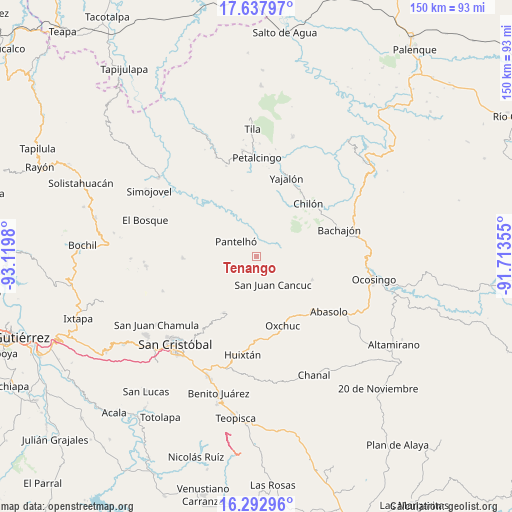
Tenango GPS coordinates[2]
16° 58' 0.012" North, 92° 25' 0.012" West
| Map corner | latitude | longitude |
|---|---|---|
| Upper-left | 17.63797°, | -93.1198° |
| Center: | 16.96667°, | -92.41667° |
| Lower-right: | 16.29296°, | -91.71355° |
| Map W x H: | 149.6×149.6 km | = 93×93mi |
| max Lat: | 32.7° ⇑89.4% North |
| Tenango: | 16.96667° |
| min Lat: | ⇓10.6% South 14.53588° |
| min Long | Tenango | max Long |
| -117.105° | -92.41667° | -86.73105° |
| W 92.6%⇐ | ⇒7.4% E |
Elevation
Elevation of Tenango is 1880 m = 6168 ft, and this is 626.3 m = 2055 ft above average elevation for this country.
| Max E: |
3497 m = 11473 ft | 32.4% |
| Tenango | 1880 m 6168 ft | |
| Avg. | 1253.7 m = 4113 ft | |
Min E: |
-1 m = -3 ft | 67.6% |
See also: Mexico elevation on elevation.city.
Geographical zone
Tenango is located in North Torrid zone (between Equator and Tropic of Cancer). Distance of this Northern Tropic circle is 719.4 km =447 mi to North.| Distance of | km | miles | from Tenango |
|---|---|---|---|
| North Pole | 8120.5 | 5045.8 | to North |
| Arctic Circle | 5514.7 | 3426.7 | to North |
| Tropic Cancer | 719.4 | 447 | to North |
| Equator | 1886.5 | 1172.2 | to South |


Nearby cities:
15 places around Tenango: (largest is in red/bold)
• Amaquil (Patio Amplio)
6.4 km =4 mi,  217°
217°
• Baquelchán
7.4 km =4.6 mi,  72°
72°
• Cruz Pilar
7.3 km =4.5 mi,  207°
207°
• Cruztón
2.9 km =1.8 mi,  227°
227°
• El Pozo
5.2 km =3.2 mi,  174°
174°
• Guayabal
7.5 km =4.7 mi,  252°
252°
• Iwiltic
2.4 km =1.5 mi,  308°
308°
• Juc'Nil
3.3 km =2.1 mi,  4°
4°
• La Palma Uno
5 km =3.1 mi,  79°
79°
• Miguel Utrilla (Los Chorros)
7.2 km =4.5 mi, 248°
• Oniltic
3.1 km =1.9 mi,  85°
85°
• Pantelhó
7.3 km =4.5 mi, 306°
• Tzeltal
7.2 km =4.5 mi, 245°
• Tzunjok
3.8 km =2.4 mi,  123°
123°
• Yocwitz
3.9 km =2.4 mi,  57°
57°
Sources, notices
• [Note1] Compared only with cities in Mexico existing in our database
• [Src1] Map data: © OpenStreetMap contributors (CC-BY-SA)
• [Src2] Other city data from geonames.org with taken over terms of usage.
• [Src3] Geographical zone / Annual Mean Temperature by Robert A. Rohde @ Wikipedia
