Guayabal geodata
Guayabal (Chiapas) is a populated place; located in Mexico in America/Mexico_City (GMT-6) time zone. With population of 552 people, there are 15449 cities with bigger population in this country. Compared to other cities in Mexico, 89.6% of cities are located further ↑North; 92% of cities are located further ←West and 51.4% of cities have higher elevation than Guayabal. Note1


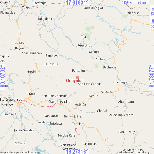
Guayabal GPS coordinates[2]
16° 56' 48.984" North, 92° 29' 2.004" West
| Map corner | latitude | longitude |
|---|---|---|
| Upper-left | 17.61831°, | -93.18702° |
| Center: | 16.94694°, | -92.48389° |
| Lower-right: | 16.27316°, | -91.78077° |
| Map W x H: | 149.6×149.6 km | = 93×93mi |
| max Lat: | 32.7° ⇑89.6% North |
| Guayabal: | 16.94694° |
| min Lat: | ⇓10.4% South 14.53588° |
| min Long | Guayabal | max Long |
| -117.105° | -92.48389° | -86.73105° |
| W 92%⇐ | ⇒8% E |
Elevation
Elevation of Guayabal is 1364 m = 4475 ft, and this is 110.3 m = 362 ft above average elevation for this country.
| Max E: |
3497 m = 11473 ft | 51.4% |
| Guayabal | 1364 m 4475 ft | |
| Avg. | 1253.7 m = 4113 ft | |
Min E: |
-1 m = -3 ft | 48.6% |
See also: Mexico elevation on elevation.city.
Geographical zone
Guayabal is located in North Torrid zone (between Equator and Tropic of Cancer). Distance of this Northern Tropic circle is 721.6 km =448.4 mi to North.| Distance of | km | miles | from Guayabal |
|---|---|---|---|
| North Pole | 8122.7 | 5047.2 | to North |
| Arctic Circle | 5516.9 | 3428 | to North |
| Tropic Cancer | 721.6 | 448.4 | to North |
| Equator | 1884.3 | 1170.8 | to South |


Nearby cities:
15 places around Guayabal: (largest is in red/bold)
• Amaquil (Patio Amplio)
4.4 km =2.7 mi,  131°
131°
• Cancuc
3.4 km =2.1 mi,  178°
178°
• Chixtontic
6.8 km =4.2 mi,  156°
156°
• Cruz Pilar
5.7 km =3.5 mi,  139°
139°
• Cruztón
5 km =3.1 mi,  87°
87°
• Iwiltic
6.5 km =4 mi,  55°
55°
• Jomanichim
5.3 km =3.3 mi,  166°
166°
• Juxalja
6 km =3.7 mi, 157°
• Miguel Utrilla (Los Chorros)
0.6 km =0.4 mi, 136°
• Pactetón
4.8 km =3 mi, 175°
• Pantelhó
6.7 km =4.2 mi,  11°
11°
• Puebla
4.1 km =2.5 mi,  211°
211°
• Tres Cerros
3.7 km =2.3 mi, 161°
• Tzeltal
1.1 km =0.7 mi, 142°
• Yibeljoj
2.4 km =1.5 mi,  299°
299°
Sources, notices
• [Note1] Compared only with cities in Mexico existing in our database
• [Src1] Map data: © OpenStreetMap contributors (CC-BY-SA)
• [Src2] Other city data from geonames.org with taken over terms of usage.
• [Src3] Geographical zone / Annual Mean Temperature by Robert A. Rohde @ Wikipedia
