Tehuipango geodata
Tehuipango (Veracruz) is a seat of a second-order administrative division; located in Mexico in America/Mexico_City (GMT-6) time zone. With population of 1,884 people, there are 4615 cities with bigger population in this country. Compared to other cities in Mexico, 72.3% of cities are located further ↑North; 74.1% of cities are located further ←West and 88.5% of cities have lower elevation than Tehuipango. Note1


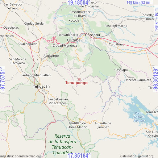
Tehuipango GPS coordinates[2]
18° 31' 10.704" North, 97° 3' 15.768" West
| Map corner | latitude | longitude |
|---|---|---|
| Upper-left | 19.18504°, | -97.75751° |
| Center: | 18.51964°, | -97.05438° |
| Lower-right: | 17.85164°, | -96.35126° |
| Map W x H: | 148.3×148.3 km | = 92.1×92.1mi |
| max Lat: | 32.7° ⇑72.3% North |
| Tehuipango: | 18.51964° |
| min Lat: | ⇓27.7% South 14.53588° |
| min Long | Tehuipango | max Long |
| -117.105° | -97.05438° | -86.73105° |
| W 74.1%⇐ | ⇒25.9% E |
Elevation
Elevation of Tehuipango is 2358 m = 7736 ft, and this is 1104.3 m = 3623 ft above average elevation for this country.
| Max E: |
3497 m = 11473 ft | 11.5% |
| Tehuipango | 2358 m 7736 ft | |
| Avg. | 1253.7 m = 4113 ft | |
Min E: |
-1 m = -3 ft | 88.5% |
See also: Mexico elevation on elevation.city.
Geographical zone
Tehuipango is located in North Torrid zone (between Equator and Tropic of Cancer). Distance of this Northern Tropic circle is 546.7 km =339.7 mi to North.| Distance of | km | miles | from Tehuipango |
|---|---|---|---|
| North Pole | 7947.9 | 4938.6 | to North |
| Arctic Circle | 5342 | 3319.4 | to North |
| Tropic Cancer | 546.7 | 339.7 | to North |
| Equator | 2059.2 | 1279.5 | to South |


Nearby cities:
15 places around Tehuipango: (largest is in red/bold)
• Apipitzactitla
2.2 km =1.4 mi,  179°
179°
• Cuauyolotitla
1 km =0.6 mi,  274°
274°
• Esperanza
3.4 km =2.1 mi,  150°
150°
• Loma Bonita
4.8 km =3 mi,  224°
224°
• Ojo de Agua
0.7 km =0.4 mi,  13°
13°
• Tecpantzacoalco
5 km =3.1 mi,  161°
161°
• Tepecuitlapa
3.8 km =2.4 mi,  206°
206°
• Tepeica
4 km =2.5 mi,  282°
282°
• Tlalixtlahuac
4.2 km =2.6 mi,  308°
308°
• Totutla
0.9 km =0.6 mi,  194°
194°
• Xaltepec
0.6 km =0.4 mi,  66°
66°
• Xiujtempa
0.7 km =0.4 mi,  325°
325°
• Xonacayojca
4.2 km =2.6 mi,  259°
259°
• Xopilapa
3.1 km =1.9 mi,  237°
237°
• Zacatlaixco
1.1 km =0.7 mi, 149°
Sources, notices
• [Note1] Compared only with cities in Mexico existing in our database
• [Src1] Map data: © OpenStreetMap contributors (CC-BY-SA)
• [Src2] Other city data from geonames.org with taken over terms of usage.
• [Src3] Geographical zone / Annual Mean Temperature by Robert A. Rohde @ Wikipedia
