Xiujtempa geodata
Xiujtempa (Veracruz) is a populated place; located in Mexico in America/Mexico_City (GMT-6) time zone. With population of 738 people, there are 11838 cities with bigger population in this country. Compared to other cities in Mexico, 72.3% of cities are located further ↑North; 74.1% of cities are located further ←West and 84.3% of cities have lower elevation than Xiujtempa. Note1


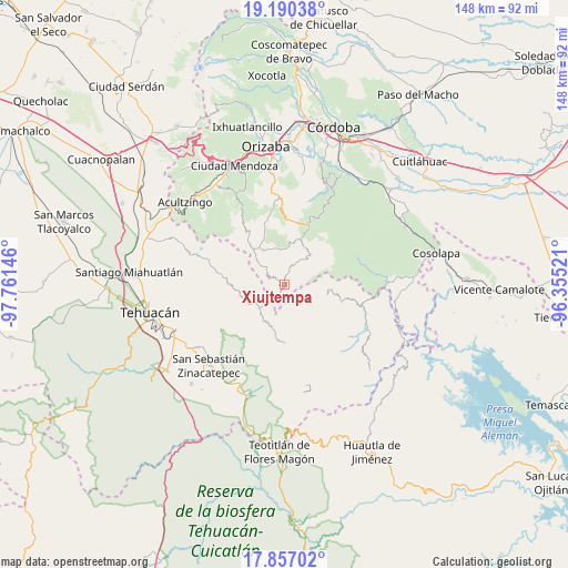
Xiujtempa GPS coordinates[2]
18° 31' 30" North, 97° 3' 29.988" West
| Map corner | latitude | longitude |
|---|---|---|
| Upper-left | 19.19038°, | -97.76146° |
| Center: | 18.525°, | -97.05833° |
| Lower-right: | 17.85702°, | -96.35521° |
| Map W x H: | 148.3×148.3 km | = 92.1×92.1mi |
| max Lat: | 32.7° ⇑72.3% North |
| Xiujtempa: | 18.525° |
| min Lat: | ⇓27.7% South 14.53588° |
| min Long | Xiujtempa | max Long |
| -117.105° | -97.05833° | -86.73105° |
| W 74.1%⇐ | ⇒25.9% E |
Elevation
Elevation of Xiujtempa is 2249 m = 7379 ft, and this is 995.3 m = 3265 ft above average elevation for this country.
| Max E: |
3497 m = 11473 ft | 15.7% |
| Xiujtempa | 2249 m 7379 ft | |
| Avg. | 1253.7 m = 4113 ft | |
Min E: |
-1 m = -3 ft | 84.3% |
See also: Mexico elevation on elevation.city.
Geographical zone
Xiujtempa is located in North Torrid zone (between Equator and Tropic of Cancer). Distance of this Northern Tropic circle is 546.1 km =339.3 mi to North.| Distance of | km | miles | from Xiujtempa |
|---|---|---|---|
| North Pole | 7947.3 | 4938.2 | to North |
| Arctic Circle | 5341.4 | 3319 | to North |
| Tropic Cancer | 546.1 | 339.3 | to North |
| Equator | 2059.8 | 1279.9 | to South |


Nearby cities:
15 places around Xiujtempa: (largest is in red/bold)
• Apipitzactitla
2.9 km =1.8 mi,  171°
171°
• Cuauyolotitla
0.8 km =0.5 mi,  226°
226°
• Esperanza
4.1 km =2.5 mi,  149°
149°
• Loma Bonita
5 km =3.1 mi,  215°
215°
• Ojo de Agua
0.6 km =0.4 mi,  78°
78°
• Tecpantzacoalco
5.7 km =3.5 mi,  159°
159°
• Tehuipango
0.7 km =0.4 mi, 145°
• Tepecuitlapa
4.2 km =2.6 mi,  197°
197°
• Tepeica
3.6 km =2.2 mi,  273°
273°
• Tlalixtlahuac
3.5 km =2.2 mi,  304°
304°
• Totutla
1.5 km =0.9 mi, 173°
• Xaltepec
1.1 km =0.7 mi,  108°
108°
• Xonacayojca
4 km =2.5 mi,  250°
250°
• Xopilapa
3.2 km =2 mi, 224°
• Zacatlaixco
1.8 km =1.1 mi, 147°
Sources, notices
• [Note1] Compared only with cities in Mexico existing in our database
• [Src1] Map data: © OpenStreetMap contributors (CC-BY-SA)
• [Src2] Other city data from geonames.org with taken over terms of usage.
• [Src3] Geographical zone / Annual Mean Temperature by Robert A. Rohde @ Wikipedia
