Esperanza geodata
Esperanza (Puebla) is a populated place; located in Mexico in America/Mexico_City (GMT-6) time zone. With population of 579 people, there are 14804 cities with bigger population in this country. Compared to other cities in Mexico, 72.7% of cities are located further ↑North; 74.4% of cities are located further ←West and 82.2% of cities have lower elevation than Esperanza. Note1


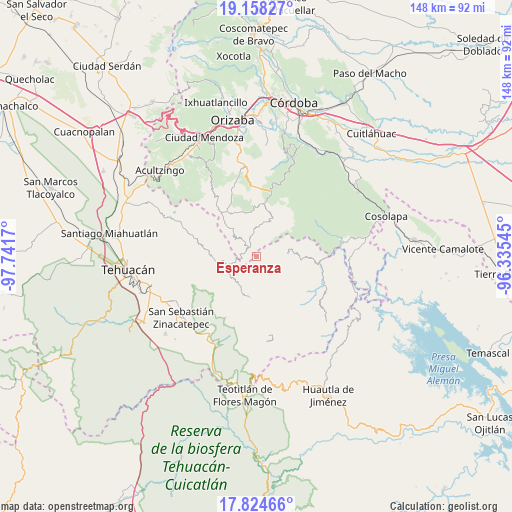
Esperanza GPS coordinates[2]
18° 29' 33.936" North, 97° 2' 18.852" West
| Map corner | latitude | longitude |
|---|---|---|
| Upper-left | 19.15827°, | -97.7417° |
| Center: | 18.49276°, | -97.03857° |
| Lower-right: | 17.82466°, | -96.33545° |
| Map W x H: | 148.3×148.3 km | = 92.1×92.1mi |
| max Lat: | 32.7° ⇑72.7% North |
| Esperanza: | 18.49276° |
| min Lat: | ⇓27.3% South 14.53588° |
| min Long | Esperanza | max Long |
| -117.105° | -97.03857° | -86.73105° |
| W 74.4%⇐ | ⇒25.6% E |
Elevation
Elevation of Esperanza is 2193 m = 7195 ft, and this is 939.3 m = 3082 ft above average elevation for this country.
| Max E: |
3497 m = 11473 ft | 17.8% |
| Esperanza | 2193 m 7195 ft | |
| Avg. | 1253.7 m = 4113 ft | |
Min E: |
-1 m = -3 ft | 82.2% |
See also: Mexico elevation on elevation.city.
Geographical zone
Esperanza is located in North Torrid zone (between Equator and Tropic of Cancer). Distance of this Northern Tropic circle is 549.7 km =341.6 mi to North.| Distance of | km | miles | from Esperanza |
|---|---|---|---|
| North Pole | 7950.9 | 4940.5 | to North |
| Arctic Circle | 5345 | 3321.2 | to North |
| Tropic Cancer | 549.7 | 341.6 | to North |
| Equator | 2056.2 | 1277.7 | to South |


Nearby cities:
15 places around Esperanza: (largest is in red/bold)
• Apipitzactitla
1.8 km =1.1 mi,  294°
294°
• Coxolico
4.7 km =2.9 mi,  168°
168°
• Cuahuichotla
4.2 km =2.6 mi,  222°
222°
• Cuauyolotitla
4 km =2.5 mi,  319°
319°
• Cuaxuxpa
3.4 km =2.1 mi, 174°
• Ojo de Agua
4 km =2.5 mi,  337°
337°
• Rancho Nuevo
4.4 km =2.7 mi,  211°
211°
• Tecpantzacoalco
1.8 km =1.1 mi,  182°
182°
• Tehuipango
3.4 km =2.1 mi,  330°
330°
• Tepecuitlapa
3.4 km =2.1 mi,  263°
263°
• Totutla
2.8 km =1.7 mi, 317°
• Xaltepec
3.4 km =2.1 mi, 341°
• Xiujtempa
4.1 km =2.5 mi, 329°
• Xopilapa
4.5 km =2.8 mi, 287°
• Zacatlaixco
2.3 km =1.4 mi, 331°
Sources, notices
• [Note1] Compared only with cities in Mexico existing in our database
• [Src1] Map data: © OpenStreetMap contributors (CC-BY-SA)
• [Src2] Other city data from geonames.org with taken over terms of usage.
• [Src3] Geographical zone / Annual Mean Temperature by Robert A. Rohde @ Wikipedia
