Villa Tecolutilla geodata
Villa Tecolutilla (Tabasco) is a populated place; located in Mexico in America/Mexico_City (GMT-6) time zone. With population of 10,637 people, there are 893 cities with bigger population in this country. Compared to other cities in Mexico, 75.1% of cities are located further ↑North; 87.1% of cities are located further ←West and 96.3% of cities have higher elevation than Villa Tecolutilla. Note1


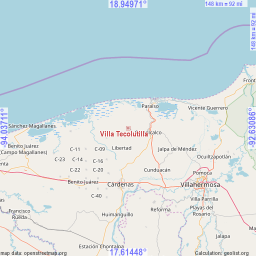
Villa Tecolutilla GPS coordinates[2]
18° 17' 0.168" North, 93° 20' 2.328" West
| Map corner | latitude | longitude |
|---|---|---|
| Upper-left | 18.94971°, | -94.03711° |
| Center: | 18.28338°, | -93.33398° |
| Lower-right: | 17.61448°, | -92.63086° |
| Map W x H: | 148.5×148.5 km | = 92.3×92.3mi |
| max Lat: | 32.7° ⇑75.1% North |
| Villa Tecolutilla: | 18.28338° |
| min Lat: | ⇓24.9% South 14.53588° |
| min Long | Villa Tecolutil | max Long |
| -117.105° | -93.33398° | -86.73105° |
| W 87.1%⇐ | ⇒12.9% E |
Elevation
Elevation of Villa Tecolutilla is 11 m = 36 ft, and this is 1242.7 m = 4077 ft below average elevation for this country.
| Max E: |
3497 m = 11473 ft | 96.3% |
| Avg. | 1253.7 m = 4113 ft | |
| Villa Tecolutilla | 11 m = 36 ft | |
Min E: |
-1 m = -3 ft | 3.7% |
See also: Mexico elevation on elevation.city.
Geographical zone
Villa Tecolutilla is located in North Torrid zone (between Equator and Tropic of Cancer). Distance of this Northern Tropic circle is 573 km =356 mi to North.| Distance of | km | miles | from Villa Tecolutilla |
|---|---|---|---|
| North Pole | 7974.1 | 4954.9 | to North |
| Arctic Circle | 5368.3 | 3335.7 | to North |
| Tropic Cancer | 573 | 356 | to North |
| Equator | 2032.9 | 1263.2 | to South |


Nearby cities:
15 places around Villa Tecolutilla: (largest is in red/bold)
• Arena 1ra. Sección
9.8 km =6.1 mi,  200°
200°
• Betania
1.4 km =0.9 mi,  104°
104°
• Comalcalco
11.8 km =7.3 mi, 100°
• El Tortuguero
6.2 km =3.9 mi,  56°
56°
• Ignacio Gutiérrez Gómez
7.7 km =4.8 mi,  240°
240°
• Ignacio Zaragoza 1ra. Sección
5.4 km =3.4 mi,  358°
358°
• La Lucha
11.5 km =7.1 mi,  173°
173°
• Miguel Hidalgo
3.8 km =2.4 mi,  140°
140°
• Occidente (San Francisco)
10.1 km =6.3 mi, 58°
• Occidente 4ta. Sección
10.8 km =6.7 mi,  78°
78°
• Reforma
7.8 km =4.8 mi,  186°
186°
• Sargento López 2da. Sección (El Chuzo)
10.3 km =6.4 mi,  154°
154°
• Sargento López 3ra. Sección (San Jorge)
11.2 km =7 mi, 135°
• Transito Tular
9.5 km =5.9 mi,  310°
310°
• Villa Aldama
5 km =3.1 mi, 200°
Sources, notices
• [Note1] Compared only with cities in Mexico existing in our database
• [Src1] Map data: © OpenStreetMap contributors (CC-BY-SA)
• [Src2] Other city data from geonames.org with taken over terms of usage.
• [Src3] Geographical zone / Annual Mean Temperature by Robert A. Rohde @ Wikipedia
