Tetla geodata
Tetla (Tlaxcala) is a seat of a second-order administrative division; located in Mexico in America/Mexico_City (GMT-6) time zone. With population of 15,161 people, there are 636 cities with bigger population in this country. Compared to other cities in Mexico, 55.2% of cities are located further ↑North; 62.5% of cities are located further ←West and 92.1% of cities have lower elevation than Tetla. Note1


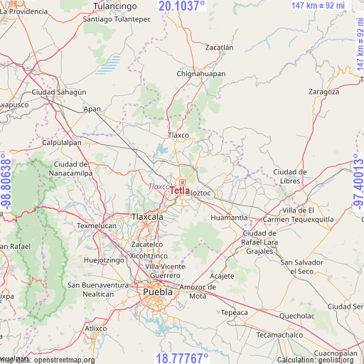
Tetla GPS coordinates[2]
19° 26' 31.344" North, 98° 6' 11.7" West
| Map corner | latitude | longitude |
|---|---|---|
| Upper-left | 20.1037°, | -98.80638° |
| Center: | 19.44204°, | -98.10325° |
| Lower-right: | 18.77767°, | -97.40013° |
| Map W x H: | 147.4×147.4 km | = 91.6×91.6mi |
| max Lat: | 32.7° ⇑55.2% North |
| Tetla: | 19.44204° |
| min Lat: | ⇓44.8% South 14.53588° |
| min Long | Tetla | max Long |
| -117.105° | -98.10325° | -86.73105° |
| W 62.5%⇐ | ⇒37.5% E |
Elevation
Elevation of Tetla is 2487 m = 8159 ft, and this is 1233.3 m = 4046 ft above average elevation for this country.
| Max E: |
3497 m = 11473 ft | 7.9% |
| Tetla | 2487 m 8159 ft | |
| Avg. | 1253.7 m = 4113 ft | |
Min E: |
-1 m = -3 ft | 92.1% |
See also: Mexico elevation on elevation.city.
Geographical zone
Tetla is located in North Torrid zone (between Equator and Tropic of Cancer). Distance of this Northern Tropic circle is 444.2 km =276 mi to North.| Distance of | km | miles | from Tetla |
|---|---|---|---|
| North Pole | 7845.3 | 4874.8 | to North |
| Arctic Circle | 5239.4 | 3255.6 | to North |
| Tropic Cancer | 444.2 | 276 | to North |
| Equator | 2161.8 | 1343.3 | to South |


Nearby cities:
15 places around Tetla: (largest is in red/bold)
• Apizaco
5.3 km =3.3 mi,  232°
232°
• Atexcatzingo
5.5 km =3.4 mi,  302°
302°
• Colonia José López Portillo
5.4 km =3.4 mi,  105°
105°
• Colonia San Isidro
3.5 km =2.2 mi,  196°
196°
• Colonia Venustiano Carranza
6.6 km =4.1 mi,  134°
134°
• Guadalupe Texcalac
2.7 km =1.7 mi,  98°
98°
• José María Morelos
6.4 km =4 mi,  294°
294°
• San Andrés Ahuashuatepec
7.1 km =4.4 mi,  182°
182°
• San José Tetel
6 km =3.7 mi,  260°
260°
• San Luis Apizaquito
2.4 km =1.5 mi,  217°
217°
• Santa Anita Huiloac
7.3 km =4.5 mi, 215°
• Santa María Texcalac
2.7 km =1.7 mi,  140°
140°
• Tzompantepec
7.5 km =4.7 mi,  169°
169°
• Xaloztoc
7.1 km =4.4 mi,  122°
122°
• Zimatepec
6.8 km =4.2 mi,  250°
250°
Sources, notices
• [Note1] Compared only with cities in Mexico existing in our database
• [Src1] Map data: © OpenStreetMap contributors (CC-BY-SA)
• [Src2] Other city data from geonames.org with taken over terms of usage.
• [Src3] Geographical zone / Annual Mean Temperature by Robert A. Rohde @ Wikipedia
