Atexcatzingo geodata
Atexcatzingo (Tlaxcala) is a populated place; located in Mexico in America/Mexico_City (GMT-6) time zone. With population of 4,504 people, there are 2042 cities with bigger population in this country. Compared to other cities in Mexico, 54.8% of cities are located further ↑North; 62% of cities are located further ←West and 92.5% of cities have lower elevation than Atexcatzingo. Note1


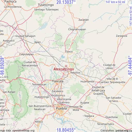
Atexcatzingo GPS coordinates[2]
19° 28' 7.752" North, 98° 8' 49.776" West
| Map corner | latitude | longitude |
|---|---|---|
| Upper-left | 20.13037°, | -98.85029° |
| Center: | 19.46882°, | -98.14716° |
| Lower-right: | 18.80455°, | -97.44404° |
| Map W x H: | 147.4×147.4 km | = 91.6×91.6mi |
| max Lat: | 32.7° ⇑54.8% North |
| Atexcatzingo: | 19.46882° |
| min Lat: | ⇓45.2% South 14.53588° |
| min Long | Atexcatzingo | max Long |
| -117.105° | -98.14716° | -86.73105° |
| W 62%⇐ | ⇒38% E |
Elevation
Elevation of Atexcatzingo is 2509 m = 8232 ft, and this is 1255.3 m = 4118 ft above average elevation for this country.
| Max E: |
3497 m = 11473 ft | 7.5% |
| Atexcatzingo | 2509 m 8232 ft | |
| Avg. | 1253.7 m = 4113 ft | |
Min E: |
-1 m = -3 ft | 92.5% |
See also: Mexico elevation on elevation.city.
Geographical zone
Atexcatzingo is located in North Torrid zone (between Equator and Tropic of Cancer). Distance of this Northern Tropic circle is 441.2 km =274.1 mi to North.| Distance of | km | miles | from Atexcatzingo |
|---|---|---|---|
| North Pole | 7842.3 | 4873 | to North |
| Arctic Circle | 5236.4 | 3253.7 | to North |
| Tropic Cancer | 441.2 | 274.1 | to North |
| Equator | 2164.7 | 1345.1 | to South |


Nearby cities:
15 places around Atexcatzingo: (largest is in red/bold)
• Apizaco
6.2 km =3.9 mi,  176°
176°
• Barrio de Cuatla
7.7 km =4.8 mi,  248°
248°
• Colonia San Isidro
7.3 km =4.5 mi,  150°
150°
• Guadalupe Texcalac
8 km =5 mi,  115°
115°
• Hualcaltzinco
7.7 km =4.8 mi,  190°
190°
• José María Morelos
1.3 km =0.8 mi, 254°
• Muñoz
6.6 km =4.1 mi,  275°
275°
• San Benito Xaltocan
7.3 km =4.5 mi,  196°
196°
• San José Tetel
4.2 km =2.6 mi, 198°
• San Luis Apizaquito
5.8 km =3.6 mi, 146°
• San Pedro Ecatepec
5.9 km =3.7 mi,  352°
352°
• Tetla
5.5 km =3.4 mi, 122°
• Topilco de Juárez
7.7 km =4.8 mi,  226°
226°
• Yauhquemehcan
7.8 km =4.8 mi,  208°
208°
• Zimatepec
5.6 km =3.5 mi, 199°
Sources, notices
• [Note1] Compared only with cities in Mexico existing in our database
• [Src1] Map data: © OpenStreetMap contributors (CC-BY-SA)
• [Src2] Other city data from geonames.org with taken over terms of usage.
• [Src3] Geographical zone / Annual Mean Temperature by Robert A. Rohde @ Wikipedia
