Santa Cruz Cuauhtenco geodata
Santa Cruz Cuauhtenco (State of Mexico) is a populated place; located in Mexico in America/Mexico_City (GMT-6) time zone. With population of 7,460 people, there are 1249 cities with bigger population in this country. Compared to other cities in Mexico, 59.9% of cities are located further ↑North; 60.6% of cities are located further →East and 98.6% of cities have lower elevation than Santa Cruz Cuauhtenco. Note1


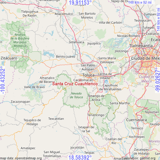
Santa Cruz Cuauhtenco GPS coordinates[2]
19° 14' 56.652" North, 99° 43' 45.804" West
| Map corner | latitude | longitude |
|---|---|---|
| Upper-left | 19.91153°, | -100.43252° |
| Center: | 19.24907°, | -99.72939° |
| Lower-right: | 18.58392°, | -99.02627° |
| Map W x H: | 147.6×147.6 km | = 91.7×91.7mi |
| max Lat: | 32.7° ⇑59.9% North |
| Santa Cruz Cuauhtenco: | 19.24907° |
| min Lat: | ⇓40.1% South 14.53588° |
| min Long | Santa Cruz Cuau | max Long |
| -117.105° | -99.72939° | -86.73105° |
| W 39.4%⇐ | ⇒60.6% E |
Elevation
Elevation of Santa Cruz Cuauhtenco is 2803 m = 9196 ft, and this is 1549.3 m = 5083 ft above average elevation for this country.
| Max E: |
3497 m = 11473 ft | 1.4% |
| Santa Cruz Cuauhtenco | 2803 m 9196 ft | |
| Avg. | 1253.7 m = 4113 ft | |
Min E: |
-1 m = -3 ft | 98.6% |
See also: Mexico elevation on elevation.city.
Geographical zone
Santa Cruz Cuauhtenco is located in North Torrid zone (between Equator and Tropic of Cancer). Distance of this Northern Tropic circle is 465.6 km =289.3 mi to North.| Distance of | km | miles | from Santa Cruz Cuauhtenco |
|---|---|---|---|
| North Pole | 7866.8 | 4888.2 | to North |
| Arctic Circle | 5260.9 | 3269 | to North |
| Tropic Cancer | 465.6 | 289.3 | to North |
| Equator | 2140.3 | 1329.9 | to South |


Nearby cities:
15 places around Santa Cruz Cuauhtenco: (largest is in red/bold)
• Cacalomacan
2.5 km =1.6 mi,  79°
79°
• Cerro del Murciélago
4.5 km =2.8 mi,  323°
323°
• Colonia Guadalupe
5.5 km =3.4 mi,  127°
127°
• Colonia Morelos
1.8 km =1.1 mi,  260°
260°
• Colonia Ricardo Flores Magón
3.7 km =2.3 mi,  305°
305°
• Colonia el Refugio
4.4 km =2.7 mi,  123°
123°
• La Joya
4.3 km =2.7 mi, 314°
• Los Rosales
3 km =1.9 mi,  37°
37°
• Recibitas (El Remolino)
3.6 km =2.2 mi,  241°
241°
• San Antonio Acahualco
5.2 km =3.2 mi,  301°
301°
• San Antonio Buenavista
2.3 km =1.4 mi,  54°
54°
• San José Barbabosa
3.1 km =1.9 mi,  18°
18°
• San Juan de las Huertas
3 km =1.9 mi,  266°
266°
• Tejalpa
3.8 km =2.4 mi, 274°
• Zinacantepec
3.9 km =2.4 mi,  353°
353°
Sources, notices
• [Note1] Compared only with cities in Mexico existing in our database
• [Src1] Map data: © OpenStreetMap contributors (CC-BY-SA)
• [Src2] Other city data from geonames.org with taken over terms of usage.
• [Src3] Geographical zone / Annual Mean Temperature by Robert A. Rohde @ Wikipedia
