Cacalomacan geodata
Cacalomacan (State of Mexico) is a populated place; located in Mexico in America/Mexico_City (GMT-6) time zone. With population of 12,001 people, there are 803 cities with bigger population in this country. Compared to other cities in Mexico, 59.8% of cities are located further ↑North; 60.3% of cities are located further →East and 98.3% of cities have lower elevation than Cacalomacan. Note1


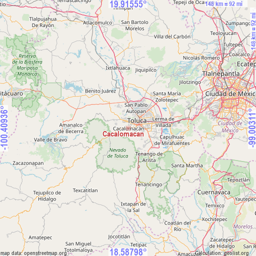
Cacalomacan GPS coordinates[2]
19° 15' 11.196" North, 99° 42' 22.428" West
| Map corner | latitude | longitude |
|---|---|---|
| Upper-left | 19.91555°, | -100.40936° |
| Center: | 19.25311°, | -99.70623° |
| Lower-right: | 18.58798°, | -99.00311° |
| Map W x H: | 147.6×147.6 km | = 91.7×91.7mi |
| max Lat: | 32.7° ⇑59.8% North |
| Cacalomacan: | 19.25311° |
| min Lat: | ⇓40.2% South 14.53588° |
| min Long | Cacalomacan | max Long |
| -117.105° | -99.70623° | -86.73105° |
| W 39.7%⇐ | ⇒60.3% E |
Elevation
Elevation of Cacalomacan is 2772 m = 9094 ft, and this is 1518.3 m = 4981 ft above average elevation for this country.
| Max E: |
3497 m = 11473 ft | 1.7% |
| Cacalomacan | 2772 m 9094 ft | |
| Avg. | 1253.7 m = 4113 ft | |
Min E: |
-1 m = -3 ft | 98.3% |
See also: Mexico elevation on elevation.city.
Geographical zone
Cacalomacan is located in North Torrid zone (between Equator and Tropic of Cancer). Distance of this Northern Tropic circle is 465.2 km =289.1 mi to North.| Distance of | km | miles | from Cacalomacan |
|---|---|---|---|
| North Pole | 7866.3 | 4887.9 | to North |
| Arctic Circle | 5260.4 | 3268.7 | to North |
| Tropic Cancer | 465.2 | 289.1 | to North |
| Equator | 2140.7 | 1330.2 | to South |


Nearby cities:
15 places around Cacalomacan: (largest is in red/bold)
• Barrio Santa María
3.8 km =2.4 mi,  127°
127°
• Barrio de la Cruz
5.1 km =3.2 mi,  93°
93°
• Colonia Guadalupe
4.3 km =2.7 mi,  153°
153°
• Colonia Loma Bonita
5.4 km =3.4 mi,  114°
114°
• Colonia Morelos
4.2 km =2.6 mi,  259°
259°
• Colonia el Mirador (Barrio del Canal)
4.7 km =2.9 mi, 134°
• Colonia el Refugio
3.2 km =2 mi,  156°
156°
• Los Rosales
2.1 km =1.3 mi,  343°
343°
• San Antonio Buenavista
1 km =0.6 mi,  325°
325°
• San Buenaventura
3.7 km =2.3 mi,  67°
67°
• San José Barbabosa
2.9 km =1.8 mi, 330°
• San Juan de las Huertas
5.5 km =3.4 mi, 263°
• Santa Cruz Cuauhtenco
2.5 km =1.6 mi, 259°
• Santiago Tlacotepec
4.7 km =2.9 mi, 127°
• Zinacantepec
4.5 km =2.8 mi,  319°
319°
Sources, notices
• [Note1] Compared only with cities in Mexico existing in our database
• [Src1] Map data: © OpenStreetMap contributors (CC-BY-SA)
• [Src2] Other city data from geonames.org with taken over terms of usage.
• [Src3] Geographical zone / Annual Mean Temperature by Robert A. Rohde @ Wikipedia
