San Sebastián geodata
San Sebastián (Morelos) is a populated place; located in Mexico in America/Mexico_City (GMT-6) time zone. With population of 5,904 people, there are 1578 cities with bigger population in this country. Compared to other cities in Mexico, 52.4% of cities are located further ↓South; 50.6% of cities are located further →East and 85.1% of cities have lower elevation than San Sebastián. Note1


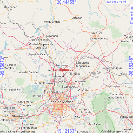
San Sebastián GPS coordinates[2]
19° 47' 3.516" North, 99° 3' 20.16" West
| Map corner | latitude | longitude |
|---|---|---|
| Upper-left | 20.44455°, | -99.75873° |
| Center: | 19.78431°, | -99.0556° |
| Lower-right: | 19.12133°, | -98.35248° |
| Map W x H: | 147.1×147.1 km | = 91.4×91.4mi |
| max Lat: | 32.7° ⇑47.6% North |
| San Sebastián: | 19.78431° |
| min Lat: | ⇓52.4% South 14.53588° |
| min Long | San Sebastián | max Long |
| -117.105° | -99.0556° | -86.73105° |
| W 49.4%⇐ | ⇒50.6% E |
Elevation
Elevation of San Sebastián is 2261 m = 7418 ft, and this is 1007.3 m = 3305 ft above average elevation for this country.
| Max E: |
3497 m = 11473 ft | 14.9% |
| San Sebastián | 2261 m 7418 ft | |
| Avg. | 1253.7 m = 4113 ft | |
Min E: |
-1 m = -3 ft | 85.1% |
See also: Mexico elevation on elevation.city.
Geographical zone
San Sebastián is located in North Torrid zone (between Equator and Tropic of Cancer). Distance of this Northern Tropic circle is 406.1 km =252.3 mi to North.| Distance of | km | miles | from San Sebastián |
|---|---|---|---|
| North Pole | 7807.3 | 4851.2 | to North |
| Arctic Circle | 5201.4 | 3232 | to North |
| Tropic Cancer | 406.1 | 252.3 | to North |
| Equator | 2199.8 | 1366.9 | to South |


Nearby cities:
15 places around San Sebastián: (largest is in red/bold)
• Arbolada los Sauces
3.7 km =2.3 mi,  18°
18°
• Buenavista
2.5 km =1.6 mi,  29°
29°
• Colonia los Hornos
2.7 km =1.7 mi,  6°
6°
• El Llano Santa María
3.2 km =2 mi,  269°
269°
• Fraccionamiento la Trinidad
5.7 km =3.5 mi,  330°
330°
• Hacienda los Encinos
2.8 km =1.7 mi,  36°
36°
• Jaltenco
5.3 km =3.3 mi,  229°
229°
• Las Plazas
4 km =2.5 mi, 33°
• Paseos de San Juan
4 km =2.5 mi,  93°
93°
• Pueblo Nuevo de Morelos
2.4 km =1.5 mi,  175°
175°
• San Bartolo Cuautlalpan
5.8 km =3.6 mi,  54°
54°
• San Juan Pueblo Nuevo
3.9 km =2.4 mi,  104°
104°
• Santa Ana Nextlalpan
5.2 km =3.2 mi,  203°
203°
• Unidad Familiar Confederación de Trabajadores Campesinos
2.6 km =1.6 mi,  251°
251°
• Zumpango
4.8 km =3 mi,  286°
286°
Sources, notices
• [Note1] Compared only with cities in Mexico existing in our database
• [Src1] Map data: © OpenStreetMap contributors (CC-BY-SA)
• [Src2] Other city data from geonames.org with taken over terms of usage.
• [Src3] Geographical zone / Annual Mean Temperature by Robert A. Rohde @ Wikipedia
