Paseos de San Juan geodata
Paseos de San Juan (State of Mexico) is a populated place; located in Mexico in America/Mexico_City (GMT-6) time zone. With population of 10,050 people, there are 948 cities with bigger population in this country. Compared to other cities in Mexico, 52.3% of cities are located further ↓South; 50.1% of cities are located further →East and 84.6% of cities have lower elevation than Paseos de San Juan. Note1


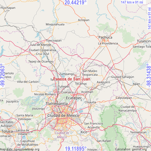
Paseos de San Juan GPS coordinates[2]
19° 46' 54.984" North, 99° 1' 3" West
| Map corner | latitude | longitude |
|---|---|---|
| Upper-left | 20.44219°, | -99.72063° |
| Center: | 19.78194°, | -99.0175° |
| Lower-right: | 19.11895°, | -98.31438° |
| Map W x H: | 147.1×147.1 km | = 91.4×91.4mi |
| max Lat: | 32.7° ⇑47.7% North |
| Paseos de San Juan: | 19.78194° |
| min Lat: | ⇓52.3% South 14.53588° |
| min Long | Paseos de San J | max Long |
| -117.105° | -99.0175° | -86.73105° |
| W 49.9%⇐ | ⇒50.1% E |
Elevation
Elevation of Paseos de San Juan is 2253 m = 7392 ft, and this is 999.3 m = 3279 ft above average elevation for this country.
| Max E: |
3497 m = 11473 ft | 15.4% |
| Paseos de San Juan | 2253 m 7392 ft | |
| Avg. | 1253.7 m = 4113 ft | |
Min E: |
-1 m = -3 ft | 84.6% |
See also: Mexico elevation on elevation.city.
Geographical zone
Paseos de San Juan is located in North Torrid zone (between Equator and Tropic of Cancer). Distance of this Northern Tropic circle is 406.4 km =252.5 mi to North.| Distance of | km | miles | from Paseos de San Juan |
|---|---|---|---|
| North Pole | 7807.5 | 4851.4 | to North |
| Arctic Circle | 5201.6 | 3232.1 | to North |
| Tropic Cancer | 406.4 | 252.5 | to North |
| Equator | 2199.5 | 1366.7 | to South |


Nearby cities:
15 places around Paseos de San Juan: (largest is in red/bold)
• Arbolada los Sauces
4.7 km =2.9 mi,  323°
323°
• Buenavista
3.7 km =2.3 mi,  311°
311°
• Colonia San Juan de Guadalupe
4.2 km =2.6 mi,  36°
36°
• Colonia los Alcanfores
4.8 km =3 mi,  1°
1°
• Colonia los Hornos
4.7 km =2.9 mi, 308°
• Ex-Hacienda de Guadalupe
5.6 km =3.5 mi,  57°
57°
• Hacienda los Encinos
3.4 km =2.1 mi, 316°
• Las Plazas
4 km =2.5 mi,  334°
334°
• Pueblo Nuevo de Morelos
4.4 km =2.7 mi,  240°
240°
• Reyes Acozac
3.9 km =2.4 mi,  100°
100°
• San Bartolo Cuautlalpan
3.8 km =2.4 mi,  11°
11°
• San Juan Pueblo Nuevo
0.7 km =0.4 mi,  199°
199°
• San Sebastián
4 km =2.5 mi,  273°
273°
• Sanata Lucía
5.4 km =3.4 mi,  134°
134°
• Santa María Ajoloapan
6.4 km =4 mi,  108°
108°
Sources, notices
• [Note1] Compared only with cities in Mexico existing in our database
• [Src1] Map data: © OpenStreetMap contributors (CC-BY-SA)
• [Src2] Other city data from geonames.org with taken over terms of usage.
• [Src3] Geographical zone / Annual Mean Temperature by Robert A. Rohde @ Wikipedia
