San Miguel Balderas geodata
San Miguel Balderas (Morelos) is a populated place; located in Mexico in America/Mexico_City (GMT-6) time zone. With population of 4,866 people, there are 1901 cities with bigger population in this country. Compared to other cities in Mexico, 62.9% of cities are located further ↑North; 59.5% of cities are located further →East and 99.1% of cities have lower elevation than San Miguel Balderas. Note1


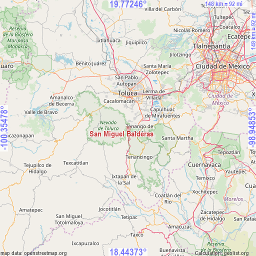
San Miguel Balderas GPS coordinates[2]
19° 6' 33.948" North, 99° 39' 5.94" West
| Map corner | latitude | longitude |
|---|---|---|
| Upper-left | 19.77246°, | -100.35478° |
| Center: | 19.10943°, | -99.65165° |
| Lower-right: | 18.44373°, | -98.94853° |
| Map W x H: | 147.7×147.7 km | = 91.8×91.8mi |
| max Lat: | 32.7° ⇑62.9% North |
| San Miguel Balderas: | 19.10943° |
| min Lat: | ⇓37.1% South 14.53588° |
| min Long | San Miguel Bald | max Long |
| -117.105° | -99.65165° | -86.73105° |
| W 40.5%⇐ | ⇒59.5% E |
Elevation
Elevation of San Miguel Balderas is 2857 m = 9373 ft, and this is 1603.3 m = 5260 ft above average elevation for this country.
| Max E: |
3497 m = 11473 ft | 0.90000000000001% |
| San Miguel Balderas | 2857 m 9373 ft | |
| Avg. | 1253.7 m = 4113 ft | |
Min E: |
-1 m = -3 ft | 99.1% |
See also: Mexico elevation on elevation.city.
Geographical zone
San Miguel Balderas is located in North Torrid zone (between Equator and Tropic of Cancer). Distance of this Northern Tropic circle is 481.1 km =298.9 mi to North.| Distance of | km | miles | from San Miguel Balderas |
|---|---|---|---|
| North Pole | 7882.3 | 4897.8 | to North |
| Arctic Circle | 5276.4 | 3278.6 | to North |
| Tropic Cancer | 481.1 | 298.9 | to North |
| Equator | 2124.8 | 1320.3 | to South |


Nearby cities:
15 places around San Miguel Balderas: (largest is in red/bold)
• Colonia Azteca
3.5 km =2.2 mi,  184°
184°
• Colonia Francisco Villa
3.7 km =2.3 mi,  1°
1°
• El Calvario
5.7 km =3.5 mi,  31°
31°
• El Coloso
5.8 km =3.6 mi,  102°
102°
• Las Cruces
5.2 km =3.2 mi,  109°
109°
• Las Jarillas
3.7 km =2.3 mi,  346°
346°
• Monte Calvario
5.9 km =3.7 mi, 95°
• San Bartolomé Atlatlahuca
6.2 km =3.9 mi,  135°
135°
• San Diego la Huerta
4.4 km =2.7 mi, 26°
• San Francisco Putla
2.6 km =1.6 mi,  39°
39°
• San Francisco Tetetla
5.3 km =3.3 mi,  81°
81°
• San Pedro Tlanixco
5.2 km =3.2 mi, 180°
• Santa Cruz Pueblo Nuevo
1.3 km =0.8 mi,  197°
197°
• Santa Cruz Pueblo Nuevo (Pueblo Nuevo)
1.2 km =0.7 mi,  212°
212°
• Zaragoza de Guadalupe
4.4 km =2.7 mi,  10°
10°
Sources, notices
• [Note1] Compared only with cities in Mexico existing in our database
• [Src1] Map data: © OpenStreetMap contributors (CC-BY-SA)
• [Src2] Other city data from geonames.org with taken over terms of usage.
• [Src3] Geographical zone / Annual Mean Temperature by Robert A. Rohde @ Wikipedia
