Las Jarillas geodata
Las Jarillas (State of Mexico) is a populated place; located in Mexico in America/Mexico_City (GMT-6) time zone. With population of 742 people, there are 11790 cities with bigger population in this country. Compared to other cities in Mexico, 62.3% of cities are located further ↑North; 59.6% of cities are located further →East and 99.7% of cities have lower elevation than Las Jarillas. Note1


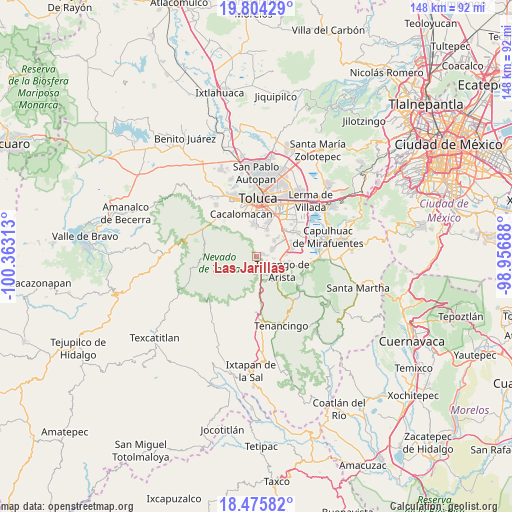
Las Jarillas GPS coordinates[2]
19° 8' 29.004" North, 99° 39' 36" West
| Map corner | latitude | longitude |
|---|---|---|
| Upper-left | 19.80429°, | -100.36313° |
| Center: | 19.14139°, | -99.66° |
| Lower-right: | 18.47582°, | -98.95688° |
| Map W x H: | 147.7×147.7 km | = 91.8×91.8mi |
| max Lat: | 32.7° ⇑62.3% North |
| Las Jarillas: | 19.14139° |
| min Lat: | ⇓37.7% South 14.53588° |
| min Long | Las Jarillas | max Long |
| -117.105° | -99.66° | -86.73105° |
| W 40.4%⇐ | ⇒59.6% E |
Elevation
Elevation of Las Jarillas is 2944 m = 9659 ft, and this is 1690.3 m = 5546 ft above average elevation for this country.
| Max E: |
3497 m = 11473 ft | 0.3% |
| Las Jarillas | 2944 m 9659 ft | |
| Avg. | 1253.7 m = 4113 ft | |
Min E: |
-1 m = -3 ft | 99.7% |
See also: Mexico elevation on elevation.city.
Geographical zone
Las Jarillas is located in North Torrid zone (between Equator and Tropic of Cancer). Distance of this Northern Tropic circle is 477.6 km =296.8 mi to North.| Distance of | km | miles | from Las Jarillas |
|---|---|---|---|
| North Pole | 7878.7 | 4895.6 | to North |
| Arctic Circle | 5272.9 | 3276.4 | to North |
| Tropic Cancer | 477.6 | 296.8 | to North |
| Equator | 2128.3 | 1322.5 | to South |


Nearby cities:
15 places around Las Jarillas: (largest is in red/bold)
• Calimaya
5 km =3.1 mi,  61°
61°
• Colonia Azteca
7.1 km =4.4 mi,  175°
175°
• Colonia Francisco Villa
1 km =0.6 mi,  82°
82°
• El Calvario
4 km =2.5 mi,  71°
71°
• Las Cruces
7.8 km =4.8 mi,  132°
132°
• San Diego la Huerta
2.8 km =1.7 mi, 82°
• San Francisco Putla
3 km =1.9 mi,  120°
120°
• San Francisco Tetetla
6.7 km =4.2 mi,  114°
114°
• San Lorenzo Cuauhtenco
6.7 km =4.2 mi,  26°
26°
• San Marcos de la Cruz
5.1 km =3.2 mi,  6°
6°
• San Miguel Balderas
3.7 km =2.3 mi,  166°
166°
• Santa Cruz Pueblo Nuevo
4.8 km =3 mi, 174°
• Santa Cruz Pueblo Nuevo (Pueblo Nuevo)
4.6 km =2.9 mi, 177°
• Villas del Campo
6.6 km =4.1 mi,  49°
49°
• Zaragoza de Guadalupe
1.8 km =1.1 mi, 65°
Sources, notices
• [Note1] Compared only with cities in Mexico existing in our database
• [Src1] Map data: © OpenStreetMap contributors (CC-BY-SA)
• [Src2] Other city data from geonames.org with taken over terms of usage.
• [Src3] Geographical zone / Annual Mean Temperature by Robert A. Rohde @ Wikipedia
