San Ildefonso geodata
San Ildefonso (State of Mexico) is a populated place; located in Mexico in America/Mexico_City (GMT-6) time zone. With population of 4,371 people, there are 2098 cities with bigger population in this country. Compared to other cities in Mexico, 52.9% of cities are located further ↑North; 61.3% of cities are located further →East and 93.1% of cities have lower elevation than San Ildefonso. Note1


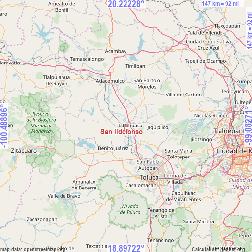
San Ildefonso GPS coordinates[2]
19° 33' 39.996" North, 99° 47' 8.988" West
| Map corner | latitude | longitude |
|---|---|---|
| Upper-left | 20.22228°, | -100.48896° |
| Center: | 19.56111°, | -99.78583° |
| Lower-right: | 18.89722°, | -99.08271° |
| Map W x H: | 147.3×147.3 km | = 91.5×91.5mi |
| max Lat: | 32.7° ⇑52.9% North |
| San Ildefonso: | 19.56111° |
| min Lat: | ⇓47.1% South 14.53588° |
| min Long | San Ildefonso | max Long |
| -117.105° | -99.78583° | -86.73105° |
| W 38.7%⇐ | ⇒61.3% E |
Elevation
Elevation of San Ildefonso is 2539 m = 8330 ft, and this is 1285.3 m = 4217 ft above average elevation for this country.
| Max E: |
3497 m = 11473 ft | 6.9% |
| San Ildefonso | 2539 m 8330 ft | |
| Avg. | 1253.7 m = 4113 ft | |
Min E: |
-1 m = -3 ft | 93.1% |
See also: Mexico elevation on elevation.city.
Geographical zone
San Ildefonso is located in North Torrid zone (between Equator and Tropic of Cancer). Distance of this Northern Tropic circle is 430.9 km =267.7 mi to North.| Distance of | km | miles | from San Ildefonso |
|---|---|---|---|
| North Pole | 7832.1 | 4866.6 | to North |
| Arctic Circle | 5226.2 | 3247.4 | to North |
| Tropic Cancer | 430.9 | 267.7 | to North |
| Equator | 2175 | 1351.5 | to South |


Nearby cities:
15 places around San Ildefonso: (largest is in red/bold)
• Barrio San Joaquín el Junco
1.4 km =0.9 mi,  75°
75°
• Barrio de San Pedro la Cabecera
3.8 km =2.4 mi, 82°
• Colonia San Francisco de Asís
3.8 km =2.4 mi,  59°
59°
• Dolores Enyege
6.6 km =4.1 mi,  278°
278°
• El Rincón de los Perales
4.9 km =3 mi,  244°
244°
• Emiliano Zapata (Santo Domingo)
2.1 km =1.3 mi,  353°
353°
• Guadalupe Cachi
6.1 km =3.8 mi,  317°
317°
• Ixtlahuaca de Rayón
2.2 km =1.4 mi,  66°
66°
• La Concepción Enyege
5.8 km =3.6 mi,  273°
273°
• San Bartolo del Llano
5.7 km =3.5 mi, 55°
• San Jerónimo Ixtapantongo
3.1 km =1.9 mi,  142°
142°
• San Juan de las Manzanas
5.6 km =3.5 mi,  258°
258°
• San Lorenzo Toxico
6.3 km =3.9 mi,  157°
157°
• San Mateo Ixtlahuaca
5.3 km =3.3 mi,  342°
342°
• Santo Domingo de Guzmán
3.6 km =2.2 mi,  10°
10°
Sources, notices
• [Note1] Compared only with cities in Mexico existing in our database
• [Src1] Map data: © OpenStreetMap contributors (CC-BY-SA)
• [Src2] Other city data from geonames.org with taken over terms of usage.
• [Src3] Geographical zone / Annual Mean Temperature by Robert A. Rohde @ Wikipedia
