San Juan Copala geodata
San Juan Copala (Oaxaca) is a populated place; located in Mexico in America/Mexico_City (GMT-6) time zone. With population of 630 people, there are 13737 cities with bigger population in this country. Compared to other cities in Mexico, 86.7% of cities are located further ↑North; 64.1% of cities are located further ←West and 53.5% of cities have lower elevation than San Juan Copala. Note1


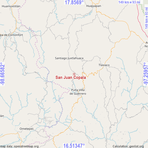
San Juan Copala GPS coordinates[2]
17° 11' 11.04" North, 97° 57' 45.684" West
| Map corner | latitude | longitude |
|---|---|---|
| Upper-left | 17.8569°, | -98.66582° |
| Center: | 17.1864°, | -97.96269° |
| Lower-right: | 16.51347°, | -97.25957° |
| Map W x H: | 149.4×149.4 km | = 92.8×92.8mi |
| max Lat: | 32.7° ⇑86.7% North |
| San Juan Copala: | 17.1864° |
| min Lat: | ⇓13.3% South 14.53588° |
| min Long | San Juan Copala | max Long |
| -117.105° | -97.96269° | -86.73105° |
| W 64.1%⇐ | ⇒35.9% E |
Elevation
Elevation of San Juan Copala is 1550 m = 5085 ft, and this is 296.3 m = 972 ft above average elevation for this country.
| Max E: |
3497 m = 11473 ft | 46.5% |
| San Juan Copala | 1550 m 5085 ft | |
| Avg. | 1253.7 m = 4113 ft | |
Min E: |
-1 m = -3 ft | 53.5% |
See also: Mexico elevation on elevation.city.
Geographical zone
San Juan Copala is located in North Torrid zone (between Equator and Tropic of Cancer). Distance of this Northern Tropic circle is 695 km =431.9 mi to North.| Distance of | km | miles | from San Juan Copala |
|---|---|---|---|
| North Pole | 8096.1 | 5030.7 | to North |
| Arctic Circle | 5490.2 | 3411.5 | to North |
| Tropic Cancer | 695 | 431.9 | to North |
| Equator | 1910.9 | 1187.4 | to South |


Nearby cities:
15 places around San Juan Copala: (largest is in red/bold)
• Concepción Carrizal
8.3 km =5.2 mi,  115°
115°
• El Rastrojo
3.2 km =2 mi,  169°
169°
• La Laguna Guadalupe
12 km =7.5 mi,  92°
92°
• La Sabana
1.2 km =0.7 mi,  16°
16°
• Río Metates
7.7 km =4.8 mi,  197°
197°
• San Andrés Chicahuaxtla
13.7 km =8.5 mi,  103°
103°
• San Martín Itunyoso
9.9 km =6.2 mi,  61°
61°
• San Miguel Copala
14.3 km =8.9 mi, 165°
• San Miguel Cuevas
11.3 km =7 mi,  305°
305°
• Santa María Asunción
7.3 km =4.5 mi,  328°
328°
• Santa María Yucunicoco
7.5 km =4.7 mi,  40°
40°
• Santa Rosa Caxtlahuaca
14.2 km =8.8 mi,  336°
336°
• Santiago Naranjos
10.4 km =6.5 mi, 330°
• Santo Domingo del Estado
12.6 km =7.8 mi,  105°
105°
• Tierra Blanca
6.8 km =4.2 mi,  126°
126°
Sources, notices
• [Note1] Compared only with cities in Mexico existing in our database
• [Src1] Map data: © OpenStreetMap contributors (CC-BY-SA)
• [Src2] Other city data from geonames.org with taken over terms of usage.
• [Src3] Geographical zone / Annual Mean Temperature by Robert A. Rohde @ Wikipedia
