San Miguel Copala geodata
San Miguel Copala (Oaxaca) is a populated place; located in Mexico in America/Mexico_City (GMT-6) time zone. With population of 677 people, there are 12831 cities with bigger population in this country. Compared to other cities in Mexico, 88.1% of cities are located further ↑North; 64.5% of cities are located further ←West and 62.1% of cities have higher elevation than San Miguel Copala. Note1


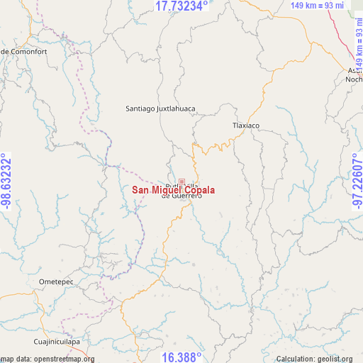
San Miguel Copala GPS coordinates[2]
17° 3' 40.968" North, 97° 55' 45.084" West
| Map corner | latitude | longitude |
|---|---|---|
| Upper-left | 17.73234°, | -98.63232° |
| Center: | 17.06138°, | -97.92919° |
| Lower-right: | 16.388°, | -97.22607° |
| Map W x H: | 149.5×149.5 km | = 92.9×92.9mi |
| max Lat: | 32.7° ⇑88.1% North |
| San Miguel Copala: | 17.06138° |
| min Lat: | ⇓11.9% South 14.53588° |
| min Long | San Miguel Copa | max Long |
| -117.105° | -97.92919° | -86.73105° |
| W 64.5%⇐ | ⇒35.5% E |
Elevation
Elevation of San Miguel Copala is 880 m = 2887 ft, and this is 373.7 m = 1226 ft below average elevation for this country.
| Max E: |
3497 m = 11473 ft | 62.1% |
| Avg. | 1253.7 m = 4113 ft | |
| San Miguel Copala | 880 m = 2887 ft | |
Min E: |
-1 m = -3 ft | 37.9% |
See also: Mexico elevation on elevation.city.
Geographical zone
San Miguel Copala is located in North Torrid zone (between Equator and Tropic of Cancer). Distance of this Northern Tropic circle is 708.9 km =440.5 mi to North.| Distance of | km | miles | from San Miguel Copala |
|---|---|---|---|
| North Pole | 8110 | 5039.3 | to North |
| Arctic Circle | 5504.1 | 3420.1 | to North |
| Tropic Cancer | 708.9 | 440.5 | to North |
| Equator | 1897 | 1178.7 | to South |


Nearby cities:
15 places around San Miguel Copala: (largest is in red/bold)
• Concepción Carrizal
11.1 km =6.9 mi,  20°
20°
• Concepción del Progreso
7.3 km =4.5 mi,  103°
103°
• Constancia del Rosario
2.9 km =1.8 mi,  206°
206°
• El Rastrojo
11.1 km =6.9 mi,  344°
344°
• La Zafra
9.5 km =5.9 mi,  152°
152°
• Malpica
5.9 km =3.7 mi,  158°
158°
• Putla Villa de Guerrero
3.9 km =2.4 mi,  178°
178°
• Río Metates
8.9 km =5.5 mi,  317°
317°
• San Andrés Chicahuaxtla
14.5 km =9 mi,  42°
42°
• San Juan Copala
14.3 km =8.9 mi,  345°
345°
• San Juan Lagunas
7.1 km =4.4 mi, 181°
• San Juan Teponaxtla
8.4 km =5.2 mi,  113°
113°
• San Pedro Siniyuvi
12.7 km =7.9 mi,  132°
132°
• Santo Domingo del Estado
13.6 km =8.5 mi, 39°
• Tierra Blanca
10 km =6.2 mi,  11°
11°
Sources, notices
• [Note1] Compared only with cities in Mexico existing in our database
• [Src1] Map data: © OpenStreetMap contributors (CC-BY-SA)
• [Src2] Other city data from geonames.org with taken over terms of usage.
• [Src3] Geographical zone / Annual Mean Temperature by Robert A. Rohde @ Wikipedia
