Yauhquemehcan geodata
Yauhquemehcan (Tlaxcala) is a seat of a second-order administrative division; located in Mexico in America/Mexico_City (GMT-6) time zone. With population of 4,204 people, there are 2185 cities with bigger population in this country. Compared to other cities in Mexico, 56.1% of cities are located further ↑North; 61.5% of cities are located further ←West and 90.8% of cities have lower elevation than Yauhquemehcan. Note1


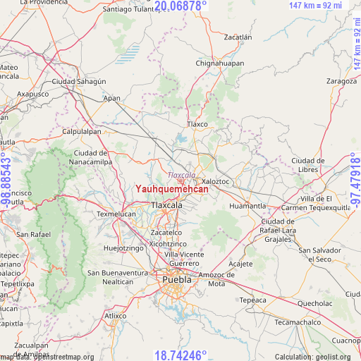
Yauhquemehcan GPS coordinates[2]
19° 24' 25.092" North, 98° 10' 56.28" West
| Map corner | latitude | longitude |
|---|---|---|
| Upper-left | 20.06878°, | -98.88543° |
| Center: | 19.40697°, | -98.1823° |
| Lower-right: | 18.74246°, | -97.47918° |
| Map W x H: | 147.5×147.5 km | = 91.7×91.7mi |
| max Lat: | 32.7° ⇑56.1% North |
| Yauhquemehcan: | 19.40697° |
| min Lat: | ⇓43.9% South 14.53588° |
| min Long | Yauhquemehcan | max Long |
| -117.105° | -98.1823° | -86.73105° |
| W 61.5%⇐ | ⇒38.5% E |
Elevation
Elevation of Yauhquemehcan is 2434 m = 7986 ft, and this is 1180.3 m = 3872 ft above average elevation for this country.
| Max E: |
3497 m = 11473 ft | 9.2% |
| Yauhquemehcan | 2434 m 7986 ft | |
| Avg. | 1253.7 m = 4113 ft | |
Min E: |
-1 m = -3 ft | 90.8% |
See also: Mexico elevation on elevation.city.
Geographical zone
Yauhquemehcan is located in North Torrid zone (between Equator and Tropic of Cancer). Distance of this Northern Tropic circle is 448.1 km =278.4 mi to North.| Distance of | km | miles | from Yauhquemehcan |
|---|---|---|---|
| North Pole | 7849.2 | 4877.3 | to North |
| Arctic Circle | 5243.3 | 3258 | to North |
| Tropic Cancer | 448.1 | 278.4 | to North |
| Equator | 2157.9 | 1340.9 | to South |


Nearby cities:
15 places around Yauhquemehcan: (largest is in red/bold)
• Apizaco
4.1 km =2.5 mi,  80°
80°
• Barrio de Atencingo
1.7 km =1.1 mi,  140°
140°
• Barrio de Cuatla
5.3 km =3.3 mi,  319°
319°
• Hualcaltzinco
2.4 km =1.5 mi,  106°
106°
• San Benito Xaltocan
1.6 km =1 mi,  94°
94°
• San Francisco Tlacuilohcan
1.2 km =0.7 mi,  241°
241°
• San José Tepoxtla
3.9 km =2.4 mi, 136°
• San José Tetel
3.8 km =2.4 mi,  39°
39°
• San Matías Tepetomatitlán
6 km =3.7 mi,  192°
192°
• San Simón Tlatlahuquitepec
4.5 km =2.8 mi,  257°
257°
• Santa Anita Huiloac
4.6 km =2.9 mi,  116°
116°
• Santa María Atlihuetzian
3.4 km =2.1 mi,  171°
171°
• Topilco de Juárez
2.4 km =1.5 mi,  310°
310°
• Xaltocan
3.5 km =2.2 mi,  303°
303°
• Zimatepec
2.4 km =1.5 mi,  49°
49°
Sources, notices
• [Note1] Compared only with cities in Mexico existing in our database
• [Src1] Map data: © OpenStreetMap contributors (CC-BY-SA)
• [Src2] Other city data from geonames.org with taken over terms of usage.
• [Src3] Geographical zone / Annual Mean Temperature by Robert A. Rohde @ Wikipedia
