San Andrés Paxtlán geodata
San Andrés Paxtlán (Oaxaca) is a populated place; located in Mexico in America/Mexico_City (GMT-6) time zone. With population of 1,196 people, there are 7259 cities with bigger population in this country. Compared to other cities in Mexico, 96.2% of cities are located further ↑North; 79.7% of cities are located further ←West and 73.9% of cities have lower elevation than San Andrés Paxtlán. Note1


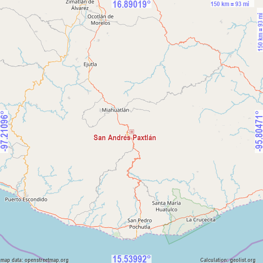
San Andrés Paxtlán GPS coordinates[2]
16° 12' 58.356" North, 96° 30' 28.188" West
| Map corner | latitude | longitude |
|---|---|---|
| Upper-left | 16.89019°, | -97.21096° |
| Center: | 16.21621°, | -96.50783° |
| Lower-right: | 15.53992°, | -95.80471° |
| Map W x H: | 150.1×150.1 km | = 93.3×93.3mi |
| max Lat: | 32.7° ⇑96.2% North |
| San Andrés Paxtlán: | 16.21621° |
| min Lat: | ⇓3.8% South 14.53588° |
| min Long | San Andrés Pax | max Long |
| -117.105° | -96.50783° | -86.73105° |
| W 79.7%⇐ | ⇒20.3% E |
Elevation
Elevation of San Andrés Paxtlán is 2010 m = 6594 ft, and this is 756.3 m = 2481 ft above average elevation for this country.
| Max E: |
3497 m = 11473 ft | 26.1% |
| San Andrés Paxtlán | 2010 m 6594 ft | |
| Avg. | 1253.7 m = 4113 ft | |
Min E: |
-1 m = -3 ft | 73.9% |
See also: Mexico elevation on elevation.city.
Geographical zone
San Andrés Paxtlán is located in North Torrid zone (between Equator and Tropic of Cancer). Distance of this Northern Tropic circle is 802.8 km =498.8 mi to North.| Distance of | km | miles | from San Andrés Paxtlán |
|---|---|---|---|
| North Pole | 8204 | 5097.7 | to North |
| Arctic Circle | 5598.1 | 3478.5 | to North |
| Tropic Cancer | 802.8 | 498.8 | to North |
| Equator | 1803.1 | 1120.4 | to South |


Nearby cities:
15 places around San Andrés Paxtlán: (largest is in red/bold)
• Cieneguilla
13.6 km =8.5 mi,  106°
106°
• La Reforma
11.7 km =7.3 mi,  77°
77°
• San Ildefonso Amatlán
13.2 km =8.2 mi,  7°
7°
• San José del Pacífico
5.1 km =3.2 mi,  173°
173°
• San José del Peñasco
11.5 km =7.1 mi,  2°
2°
• San Mateo Río Hondo
10.3 km =6.4 mi,  140°
140°
• San Miguel Suchixtepec
14.2 km =8.8 mi,  162°
162°
• San Miguel Yogovana
14.9 km =9.3 mi,  297°
297°
• San Pedro Amatlán
13.8 km =8.6 mi,  27°
27°
• San Sebastián Río Hondo
5.8 km =3.6 mi,  128°
128°
• Santa Catarina Roatina
7.1 km =4.4 mi,  351°
351°
• Santa Lucía
11.7 km =7.3 mi,  254°
254°
• Santo Tomás Tamazulapam
10 km =6.2 mi,  307°
307°
• Sitio de Xitlapehua
15.3 km =9.5 mi, 350°
• Yojuela
11.8 km =7.3 mi,  60°
60°
Sources, notices
• [Note1] Compared only with cities in Mexico existing in our database
• [Src1] Map data: © OpenStreetMap contributors (CC-BY-SA)
• [Src2] Other city data from geonames.org with taken over terms of usage.
• [Src3] Geographical zone / Annual Mean Temperature by Robert A. Rohde @ Wikipedia
