San Ildefonso Amatlán geodata
San Ildefonso Amatlán (Oaxaca) is a seat of a second-order administrative division; located in Mexico in America/Mexico_City (GMT-6) time zone. With population of 883 people, there are 9888 cities with bigger population in this country. Compared to other cities in Mexico, 95.4% of cities are located further ↑North; 79.8% of cities are located further ←West and 53.3% of cities have lower elevation than San Ildefonso Amatlán. Note1


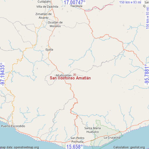
San Ildefonso Amatlán GPS coordinates[2]
16° 20' 2.04" North, 96° 29' 28.392" West
| Map corner | latitude | longitude |
|---|---|---|
| Upper-left | 17.00747°, | -97.19435° |
| Center: | 16.3339°, | -96.49122° |
| Lower-right: | 15.658°, | -95.7881° |
| Map W x H: | 150×150 km | = 93.2×93.2mi |
| max Lat: | 32.7° ⇑95.4% North |
| San Ildefonso Amatlán: | 16.3339° |
| min Lat: | ⇓4.6% South 14.53588° |
| min Long | San Ildefonso A | max Long |
| -117.105° | -96.49122° | -86.73105° |
| W 79.8%⇐ | ⇒20.2% E |
Elevation
Elevation of San Ildefonso Amatlán is 1546 m = 5072 ft, and this is 292.3 m = 959 ft above average elevation for this country.
| Max E: |
3497 m = 11473 ft | 46.7% |
| San Ildefonso Amatlán | 1546 m 5072 ft | |
| Avg. | 1253.7 m = 4113 ft | |
Min E: |
-1 m = -3 ft | 53.3% |
See also: Mexico elevation on elevation.city.
Geographical zone
San Ildefonso Amatlán is located in North Torrid zone (between Equator and Tropic of Cancer). Distance of this Northern Tropic circle is 789.8 km =490.8 mi to North.| Distance of | km | miles | from San Ildefonso Amatlán |
|---|---|---|---|
| North Pole | 8190.9 | 5089.6 | to North |
| Arctic Circle | 5585 | 3470.4 | to North |
| Tropic Cancer | 789.8 | 490.8 | to North |
| Equator | 1816.2 | 1128.5 | to South |


Nearby cities:
15 places around San Ildefonso Amatlán: (largest is in red/bold)
• Bramadero
14.6 km =9.1 mi,  65°
65°
• El Costoche
13.1 km =8.1 mi,  54°
54°
• La Reforma
14.3 km =8.9 mi,  137°
137°
• Miahuatlán de Porfirio Díaz
11.1 km =6.9 mi,  269°
269°
• San Andrés Paxtlán
13.2 km =8.2 mi,  187°
187°
• San Cristóbal Amatlán
9.1 km =5.7 mi,  101°
101°
• San Francisco Logueche
12.3 km =7.6 mi,  79°
79°
• San José del Peñasco
2.1 km =1.3 mi,  220°
220°
• San Luis Amatlán
5.9 km =3.7 mi,  352°
352°
• San Miguel Yogovana
16.2 km =10.1 mi,  247°
247°
• San Pedro Amatlán
4.6 km =2.9 mi, 99°
• Santa Catarina Roatina
6.7 km =4.2 mi,  204°
204°
• Santo Tomás Tamazulapam
12 km =7.5 mi,  233°
233°
• Sitio de Xitlapehua
4.8 km =3 mi,  294°
294°
• Yojuela
11.2 km =7 mi,  130°
130°
Sources, notices
• [Note1] Compared only with cities in Mexico existing in our database
• [Src1] Map data: © OpenStreetMap contributors (CC-BY-SA)
• [Src2] Other city data from geonames.org with taken over terms of usage.
• [Src3] Geographical zone / Annual Mean Temperature by Robert A. Rohde @ Wikipedia
