Santo Tomás Tamazulapam geodata
Santo Tomás Tamazulapam (Oaxaca) is a populated place; located in Mexico in America/Mexico_City (GMT-6) time zone. With population of 1,559 people, there are 5538 cities with bigger population in this country. Compared to other cities in Mexico, 95.9% of cities are located further ↑North; 79.3% of cities are located further ←West and 59.2% of cities have lower elevation than Santo Tomás Tamazulapam. Note1
Current local time in Santo Tomás Tamazulapam:
11:19 AM, MondayDifference from your time zone: hours


Santo Tomás Tamazulapam GPS coordinates[2]
16° 16' 14.304" North, 96° 34' 54.948" West
| Map corner | latitude | longitude |
|---|---|---|
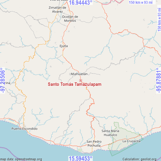
| Upper-left | 16.94443°, | -97.28506° |
| Center: | 16.27064°, | -96.58193° |
| Lower-right: | 15.59453°, | -95.87881° |
| Map W x H: | 150.1×150.1 km | = 93.3×93.3mi |
| max Lat: | 32.7° ⇑95.9% North |
| Santo Tomás Tamazulapam: | 16.27064° |
| min Lat: | ⇓4.1% South 14.53588° |
| min Long | Santo Tomás Ta | max Long |
| -117.105° | -96.58193° | -86.73105° |
| W 79.3%⇐ | ⇒20.7% E |
Elevation
Elevation of Santo Tomás Tamazulapam is 1713 m = 5620 ft, and this is 459.3 m = 1507 ft above average elevation for this country.
| Max E: |
3497 m = 11473 ft | 40.8% |
| Santo Tomás Tamazulapam | 1713 m 5620 ft | |
| Avg. | 1253.7 m = 4113 ft | |
Min E: |
-1 m = -3 ft | 59.2% |
See also: Mexico elevation on elevation.city.
Geographical zone
Santo Tomás Tamazulapam is located in North Torrid zone (between Equator and Tropic of Cancer). Distance of this Northern Tropic circle is 796.8 km =495.1 mi to North.| Distance of | km | miles | from Santo Tomás Tamazulapam |
|---|---|---|---|
| North Pole | 8197.9 | 5093.9 | to North |
| Arctic Circle | 5592 | 3474.7 | to North |
| Tropic Cancer | 796.8 | 495.1 | to North |
| Equator | 1809.1 | 1124.1 | to South |


Nearby cities:
15 places around Santo Tomás Tamazulapam: (largest is in red/bold)
• Miahuatlán de Porfirio Díaz
7.1 km =4.4 mi,  348°
348°
• Monjas
12.8 km =8 mi,  329°
329°
• San Andrés Paxtlán
10 km =6.2 mi,  127°
127°
• San Ildefonso Amatlán
12 km =7.5 mi,  53°
53°
• San José del Pacífico
14 km =8.7 mi,  142°
142°
• San José del Peñasco
9.9 km =6.2 mi,  56°
56°
• San Luis Amatlán
15.7 km =9.8 mi,  34°
34°
• San Miguel Coatlán
14.5 km =9 mi,  235°
235°
• San Miguel Yogovana
5.3 km =3.3 mi,  279°
279°
• San Pedro Amatlán
15.5 km =9.6 mi,  66°
66°
• Santa Catarina Cuixtla
7.6 km =4.7 mi,  301°
301°
• Santa Catarina Roatina
6.9 km =4.3 mi,  82°
82°
• Santa Cruz Xitla
11.4 km =7.1 mi, 300°
• Santa Lucía
9.7 km =6 mi,  200°
200°
• Sitio de Xitlapehua
10.4 km =6.5 mi, 30°
Sources, notices
• [Note1] Compared only with cities in Mexico existing in our database
• [Src1] Map data: © OpenStreetMap contributors (CC-BY-SA)
• [Src2] Other city data from geonames.org with taken over terms of usage.
• [Src3] Geographical zone / Annual Mean Temperature by Robert A. Rohde @ Wikipedia
