Remojadas geodata
Remojadas (Veracruz) is a populated place; located in Mexico in America/Mexico_City (GMT-6) time zone. With population of 835 people, there are 10477 cities with bigger population in this country. Compared to other cities in Mexico, 63.4% of cities are located further ↑North; 80.3% of cities are located further ←West and 83.9% of cities have higher elevation than Remojadas. Note1


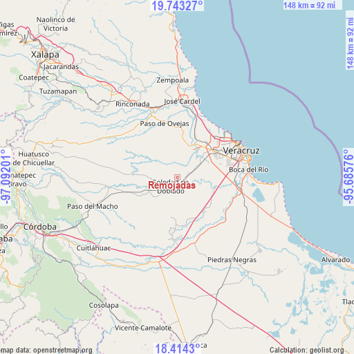
Remojadas GPS coordinates[2]
19° 4' 48.432" North, 96° 23' 19.968" West
| Map corner | latitude | longitude |
|---|---|---|
| Upper-left | 19.74327°, | -97.09201° |
| Center: | 19.08012°, | -96.38888° |
| Lower-right: | 18.4143°, | -95.68576° |
| Map W x H: | 147.8×147.8 km | = 91.8×91.8mi |
| max Lat: | 32.7° ⇑63.4% North |
| Remojadas: | 19.08012° |
| min Lat: | ⇓36.6% South 14.53588° |
| min Long | Remojadas | max Long |
| -117.105° | -96.38888° | -86.73105° |
| W 80.3%⇐ | ⇒19.7% E |
Elevation
Elevation of Remojadas is 52 m = 171 ft, and this is 1201.7 m = 3943 ft below average elevation for this country.
| Max E: |
3497 m = 11473 ft | 83.9% |
| Avg. | 1253.7 m = 4113 ft | |
| Remojadas | 52 m = 171 ft | |
Min E: |
-1 m = -3 ft | 16.1% |
See also: Mexico elevation on elevation.city.
Geographical zone
Remojadas is located in North Torrid zone (between Equator and Tropic of Cancer). Distance of this Northern Tropic circle is 484.4 km =301 mi to North.| Distance of | km | miles | from Remojadas |
|---|---|---|---|
| North Pole | 7885.6 | 4899.9 | to North |
| Arctic Circle | 5279.7 | 3280.7 | to North |
| Tropic Cancer | 484.4 | 301 | to North |
| Equator | 2121.5 | 1318.2 | to South |


Nearby cities:
15 places around Remojadas: (largest is in red/bold)
• Bandera de Juárez
13.6 km =8.5 mi,  344°
344°
• Belisario Domínguez
11.5 km =7.1 mi,  28°
28°
• Cabo Verde
13.8 km =8.6 mi,  42°
42°
• El Buzón
9.5 km =5.9 mi, 25°
• El Sauce
3.1 km =1.9 mi,  45°
45°
• Loma de los Carmona
2.9 km =1.8 mi,  349°
349°
• Loma del Nanche
13.5 km =8.4 mi,  1°
1°
• Manlio Fabio Altamirano
6 km =3.7 mi,  74°
74°
• Mata Cazuela
10 km =6.2 mi,  319°
319°
• Mata Loma
11.3 km =7 mi,  59°
59°
• Paso Lagarto
12.5 km =7.8 mi,  280°
280°
• Paso Real
11.8 km =7.3 mi,  13°
13°
• Puente Jula
14 km =8.7 mi,  17°
17°
• Soledad de Doblado
5.1 km =3.2 mi,  222°
222°
• Tenenexpan
6.8 km =4.2 mi, 354°
Sources, notices
• [Note1] Compared only with cities in Mexico existing in our database
• [Src1] Map data: © OpenStreetMap contributors (CC-BY-SA)
• [Src2] Other city data from geonames.org with taken over terms of usage.
• [Src3] Geographical zone / Annual Mean Temperature by Robert A. Rohde @ Wikipedia
